
Torry Route
Bridge Street to Torry Established 1904 – c.1906 Appraisal
Route – Bridge Street, Guild Street, Market Street, Victoria Road, & Balnagask Road.
Where Twin Cities, rising in Twin Valleys, the one famous for its Commerce, the other for its Learning, seem as if they touched the Sky with their Twin Towers. – John Leech, 1620.
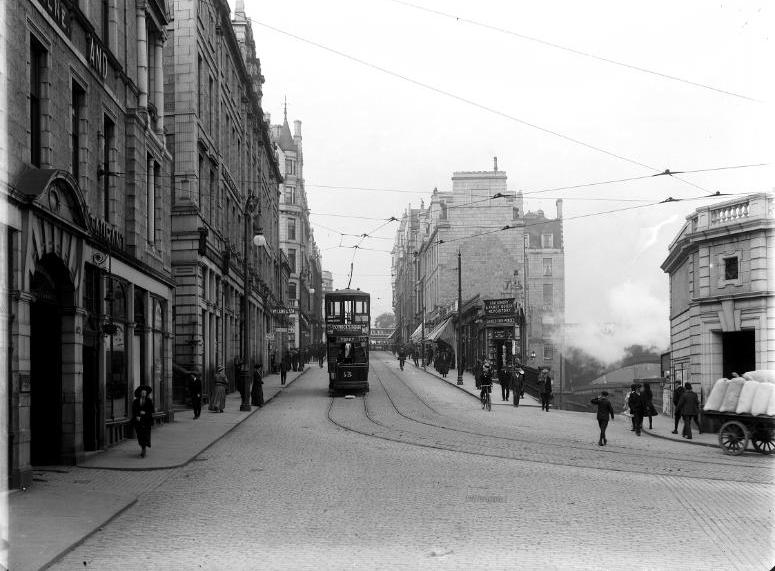
As the Car travelled the Length of Guild Street it turns into Lower Market Street there will be observed on the left the General Post Office opened in 1875, and later replaced as the Chief Office by the handsome New Buildings, in Crown Street. Further along the Regents Quay, easily distinguished by its Clock Tower, is the Harbour Offices, erected in 1885 on the Site of the Weighhouse. Built in 1634, and removed in 1883 for the Harbour Offices, soon to be built. In passing along Lower Market Street a good View of the Harbour is obtained with the Shipping, the part next to Market Street being known as Regent or Upper Dock. Aberdeen has from very early times held a high position as a Commercial Port, for so early as 1294 a dispute regarding Aberdeen Merchants and their Goods was the subject of Communications between the English & Scottish Courts. In later times, before the Union, the Trade carried on with the Continent through the Low Country Ports was, considering the means of Transport very considerable indeed. The Harbour then, and for long after, was nothing more nor less than a narrow Strip of Water forming the Channel of the Denburn, and Dredged to an average depth of 10 or 12-ft.

Up till 1829, the Administration of the Harbour was in the hands of the Town Council, but in that year a Commission was Established for the purpose, which now comprises 19-Town Councillors & 12 Elected Commissioners, chosen by Owners of Shipping & Burgesses of Guild & Trade. In 1843 Plans were prepared for New Docks & other Works, including the Diversion of the River Dee further South, so as to clear it for the New Harbour Basin. The Works were completed in 1848, and one of the 1st Arrivals in the New Docks was the Royal Yacht “Victoria & Albert,” Berthed at a Temporary Queens Jetty, Waterloo Quay with the Queen & Prince Albert, who were then about to make their 1st Acquaintance with the Balmoral Estate.
Aberdeen is connected by regular Lines of Steamers with London, Hull, Newcastle, Leith, Moray Firth Ports, Orkney & Shetland, Glasgow, & Liverpool. As showing the progress of the Trade, it may be stated that the Tonnage of Shipping entering the Port in 1855 amounted to 283,161Tons, and in 1895 it was stated at 978,231 Tons, while the Harbour Revenue for the former year was; £19,628, and for last year; £79,109. The total area of the Harbour Estate is 360-acres, of which 200-acres are in Water area, and 160-acres in Lands & Quays. The length of the Quays is about 3.25-miles.
To the left, facing the Albert Basin, is the Fish Market, then the largest in Scotland, and fast approaching in size to those of Grimsby & Hull. The Fish Market was removed from the later Post Office Site to its present Site and Opened in 1889, and has been extended on 2-occasions since then, and now measures half a mile in length. Whitefish only were sold in the Fish Market, and the best time to see the Trade in full Swing is between 8 & 9-am, when the Sales take place. As giving some idea of the dimensions of the Trade & its rapid progress, it may be remarked that there were then about 250-Steam Trawlers, Drifters, & Line Boats engaged and that while in 1887 the Value of White Fish Landed came to; £86,900, the value in 1905 was £889,206. In addition to the Whitefish, a considerable Trade in Salmon is done, to the extent of about; £25,000 a year, while at Point Law the Value of Herrings Landed during the Season would approximate to; £75,000. The Albert Basin, which was wholly given up to the Fish Trade, was originally the Bed of the River Dee, as diverted when the Harbour was formed. By an Act obtained in 1868, the struggling Courses of the River were collected, and the Mainstream diverted further Southwards into its present Channel. The expense was very great, but it resulted in the reclaiming of some valuable Land, which now produces a good Revenue for the Commissioners.


Torry Tram Route – The 1st Electric Tram Service to Torry
Established 1904 it ran from Guild Street to St Fittick’s Road with the Tram Depot just North of the Victoria Bridge. Eventually, the Torry Line was linked up with the main Network via Bridge Street, a Mirror being provided on the Single-track at the foot to enable the Driver to see around the sharp Corner to avoid any Oncoming Traffic coming down Bridge Street colliding with the leading Overhang of the Tram Bogie.
Former Tramshed/Tramway Depot built c.1905. The Building at 244-Market Street once served as a Depot for the Torry Tramway Route. The Depot, Built in 1904, was a 1-Storey tall Ashlar Building, with 1 by 6-Bays. Built of coursed Grey rough-faced Granite finely finished to the margins, with Pink Granite Base Course, moulded Lintels to windows, Pink Granite Pilastered Bays & Pink Granite Eaves Course & Cornice. The Principal, Northeast Elevation has a round-headed Tram Entrance to the Centre, Hood moulded with decorative paired Label Stops, flanked by Pilasters supporting a simple Pediment. The Southeast Elevation has 6-Pilastered Bays with regular Fenestration. The Doorway to the Bay to the left has a Plaque on the Right side reading Riverside House. It had a capacity for 6-Cars, but in 1910 this allocation was moved to the Queen’s Cross Depot and it became the Paint Shop for Dee Village Central Works; the Paint Shop was later removed to King Street Depot in 1931.
Victoria Bridge which Spans the new Channel of the River Dee, was opened in 1881, having cost over £26,000. In 1876 an unfortunate Accident occurred to the Footdee Ferry Boat, which then served as the only means of Communication, whereby 32-Lives were lost, and the Bridge: Often spoken about, was by unanimous Public Opinion projected without further delay. The District to the South of the Bridge is known as Torry, and although in the County of Kincardine it has formed part of the City since 1891. The Prosperity of this District is intimately bound up with that of the Fishing Industry, and its growth has been phenomenal. In 1891 the Population was about 2,940 & in 1906 it is estimated at 14,000. The Old Village lies to the East on the Low Ground close to the River Dee, and is Tenanted by Fishermen, who maintain a close relationship with their Brethren at Footdee.
In the days before the Bishop erected the Bridge of Dee, Travellers from the South had sometimes to wait at Torry when the River was Swollen before being able to continue their Journey Northwards. In order, therefore, that suitable Accommodation might be provided for Travellers in such a plight, James IV, in 1494, erected Torry into a Burgh of Barony, with its Cross & Right of Market, but the Privilege never seems to have been Exercised.
Aberdeen 1902 Map
At the Car Terminus in Victoria Road a fine view is obtained of the City, and of the long line of Beach curving Northwards, while here and there the Stations of the Coastguards are easily distinguished by the Line of Whitewashed Houses. Directly opposite the Terminus will be observed the various Shipbuilding Yards, which form no small part of the Industries of the City, and from these same Yards in byegone days were Launched the famous Aberdeen Clippers, which before the days of Steamships held the record for the fastest Passages home with the produce of the Indies, China & Australia.

St Fitticks Road proceeds down to the Bay of Nigg, passing on the right the ruined Kirk of St Fittick’s, of pre-Reformation date and possessing several features of Interest. Outside in the Churchyard, at the South-east corner of the Church, may be seen a Flat Gravestone, the Inscription of which reads that “William Milne, Tenant of Kincorth, slain by his Enemies on the l0th July 1645, for the cause of Christ, here Rests in Peace from his Labours. This man, who Piety, Probity, and God’s Holy Covenant made happy, fell by the Sword of a savage Irishman.” The Vane in the Old Belfry is dated 1763, while the Belfry itself has the date 1704 and the initials RM, referring to Mr Richard Maitland (1674-1719), the Minister of the Parish, regarding whom some good stories are told.
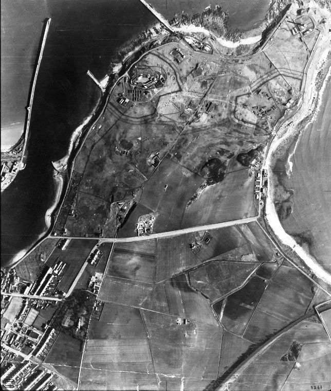
The Bay of Nigg has always been a favourite resort of the Citizens of Aberdeen, in former days by the Superstitious, who sought Cures at the Well of St Fittick, and in latter times for Health & Recreation. At the Bay was the Marine Laboratory of the Scottish Fishery Board, on passing which a new Marine Drive – Greyhope Road, was laid out by the Town Council and leads towards the Lighthouse. The Girdleness Lighthouse, which is under the charge of the Northern Lighthouse Commissioners, was 1st Lit in 1833, and was open to Visitors on certain days of the Week. The small house on the Foreshore is the Valve House connected with the City Sewage System, the Outfall being near this point. Behind the Lighthouse is the Walker Park (85-acres), laid out in 1902. On leaving the Park the small Bay to the right has the sinister name of Greyhope Bay, and in justification of the name it may be mentioned that on the 1st April, 1813, the Whaler “Oscar,” then setting out for the Arctic Whaling Grounds, was driven on the Rocks here during a Severe Storm, and out of a Crew of 43 only 2 were saved. The St Fitticks Road can be rejoined either by following the Footpath before coming to the Torry Battery, or bypassing the Fort and continuing along the Road running parallel to the Harbour Entrance, passing on the right the South Breakwater, already referred to, and turning to the left.
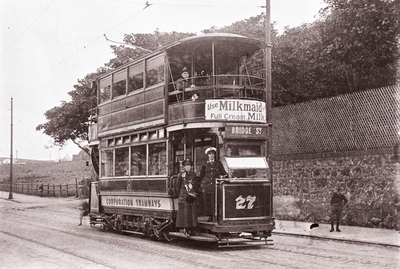
The No.27 Tram on Victoria Road with the Wall of Balnagask House Estate in the background. The Balnagask Mains Farm is partially visible to the left of the Tram. The St Fittick’s Road Terminus of the Torry Route is located further along Victoria Road. The Female Driver & Conductor indicates the Photo was taken during the WW1. The Tram waits to Depart for Bridge Street.
The Building at the Terminus is the Club House of the Balnagask Golf Club – a then a Private Course of 12-holes. On leaving the Car it is advisable that the Visitor should turn o the right and proceed down to the Bay of Nigg, passing on he right the ruined Kirk of St Fittick’s.
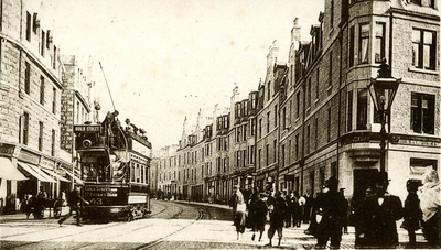
Victoria Road was one of the 1st Streets in the Development of New Torry in the late 19thC. As the Population of Aberdeen rapidly increased and advances were made in Fishing Technology there was a need for more Housing in Torry. The Torry Land Association controversially bought the Land that had previously been occupied by Torry Farm and began work on what would become the Main Street in Torry. This view taken from the Junction with Menzies Road shows the Victoria Bar on the corner. This is reputed to be the old Site of the Torry Farm Duck-Pond. The 1st Houses, Nos.104 & 110, were built by Calder Duncan & David Alexander around 1883. These Villas have since however been replaced with the type of Granite Tenements that dominate the area. In this Image the No.43 Electric Tram is clearly seen on its way from Guild Street to St Fitticks Road. Torry was one of the last places in Aberdeen to get a Tram Line, the Route being opened in 1903. Tram Wire Rosettes are still visible on the frontage of many of Torry’s Tenements today. The Rosettes are where Overhead Power Line suspensions for the Trams were fixed into the Walls. The last Tram to Torry ran in a Blizzard in February 1931. One of the Road’s historic Gas Lamps can also be seen on the near right. Victoria Road was home to many notable Residents over the years.
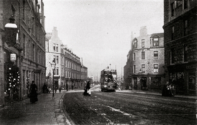
Open-Topped early Guild Street Tram No.41 at the Junction of Menzies Road/Sinclair Road & Victoria Road where the Tall Granite Tenements cast Long Shadows and is heading towards the Tram Terminus. The busy Street is Lined with Shops & Pubs
