Mounthooly ~ Original Route to the Old Town

From the Gallowgate/West North Street to Kings Crescent
Aberdeen Canal: From this point down to the Harbour, the Goods Line of the Railway keeps to the Bed of the Canal. There were several Locks on the part of the Canal bordering on Elmbank Terrace, and near the Bridge, there is in a Nursery a small Red-tiled House which was a Cabin for the Lockman who opened & closed the Locks when Barges passed up and down. At Mounthooly there was a Wharf which was the chief Town Station on the Canal. Here were delivered and taken on Goods from and to Country Merchants. After 1830 Messrs Barry, Henry, & Company crushed Bones for Manure, which were shipped here. Below Mounthooly there was another Lock, and on the upper side of the Bridge at Nelson Street, there was, on the Eastside, a place where the Barges could be repaired. Below Nelson Street, there was a wide part where 2 Barges could pass one another, and between Nelson Street & King Street, there were 2 Locks, the lower very near to King Street. From King Street downwards there were grassy slopes on both sides, which were let to householders for bleaching greens; and for the convenience of women who washed clothes on the margin of the Canal, there were small wooden Platforms, where they could dip Pails easily. The sight of women doing their Washing often gave rise to ribald gatherings of lecherous men as a Spectator Sport. Tucking their Skirts in their Bloomers and dancing on the Sheets before affordable Brassieres could contain their figures must have been quite an attraction.
Parson Gordons Map of 1661 shows it as a small Hamlet at the extreme end of the Gallowgate where the North Road led towards Old Aberdeen situated in open Grasslands of the King’s Meadows, West of Porthill (hence King’s Street & Kings Crescent). G & W Patersons Map of 1746 lists it as Mount Hodey at the South end of the Spital Road which could be a Cartographical Draughtsman’s spelling error. Alexander Milne’s Map of 1789 shows Mount Hillie on the Old Town Road.


This curiously-named Street on the left runs only a few 100 yards from its Junction with Causewayend a name that would be more appropriate 90-yrs ago and Gallowgate Head, Beyond Mounthooley the Road becomes known as King’s Crescent and, a little further on, the Spital. It is part of the Hilly & Winding but Direct Route between the new City of Aberdeen and the old Town, or Aulton. The name Mounthooly, although not unique, is not very common in Scotland. It has been conjectured that it means the Holy Mount, a Hill on which in ancient times a Chapel stood.
Monthooly, Mounthooly, Monthillie. Both parts of these names mean Hill. Monadh, hill; choille, coille asp., hill.
Several places in the County of Aberdeen have this name. In the City, it is given to the part of the Road to Old Aberdeen between Gallowgate & Canal Street


Below is a photograph of Mounthooly in 1932. On the Right is a wee Shoppie there with Proprietors called Adam & Craigmile with Nelson Street further to the left of it. They were Rose Growers & Florists, and they had Horticultural Nurseries in other parts of the City. Mitchell & Muil Bakers are also present. Bairns & grandfathers abound the Streets along with a Point-Duty Policeman with white gloves ready to direct Traffic at the busy Junction of Causewayend, Gallowgate, Nelson Street & West North Street if not contemplating arresting the Photographer.


Looking up Mounthooly it seems where West North Street, Causewayend, the Gallowgate & Nelson Street all met at a busy Junction. My Cousin David lived in the Attics top left above the Shops in spartan conditions. Directly Opposite is the Co-operative Buildings (Co-op Butchers & Grocers at No.s 218-218½) in the Gallowgate. A Bus once crushed & bent my rear bicycle wheel on yonder pavement cutting into Mounthooly and carried on leaving me bereft & isolated. Nelson Street off-picture to the right was where the Globe Cinema used to be – formerly a Church and better known as the ‘Globie‘. No doubt the later Zebra Crossing was a blessing for such a dangerous Junction. Doon the West North Street Brae to Barry Henry & Cook’s Works. Left up the road to Causewayend School.
Beyond Broad Street and the Guestrow, the old Gallowgate (route to the old Gallows location at Gallowhill) led North out of the City otherwise known as the Kings Highway via Mounthooly,Kings Crescent & the Spital to Old Aberdeen.
This cobbled ‘Cassie’ road split half a mile further on, the Main Road thereafter winding West, while a North spur climbed the ridge of Mounthooly (‘holy hill’) where Medieval Monks had once tended the Leper Hospital on the way to Old Aberdeen via the Spital Road.
Ah, my Geordie nivver stole nor calf nor cow
He nivver injured ony;
Slew 16 of the King’s Royal Deer
And selt them on Mounthooly
St Nicholas or East Poorhouse
The St Nicholas Poorhouse stood at the North side of Nelson Street, Aberdeen. In 1847, the Board of Supervision for Relief of the Poor published a Model Poorhouse Plan “originally prepared for the United Parishes of St Nicholas & Old Machar, Aberdeen, and is now about to be erected with some slight modifications, for the Parish of St Nicholas”. A bird’s eye view of the Model Poorhouse, designed by Architects Thomas Mackenzie & James Matthews, is shown below.
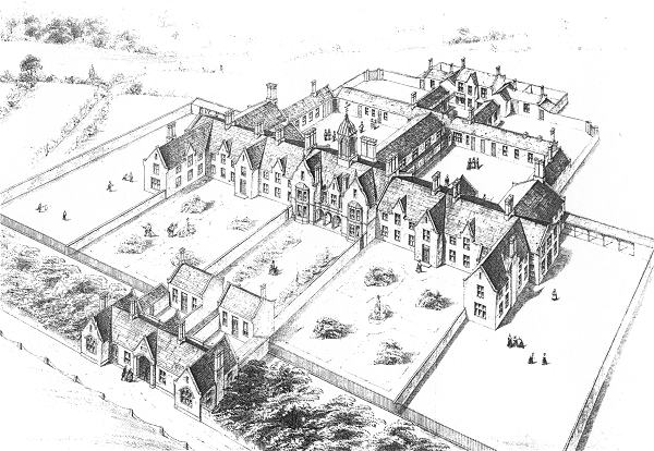
St Nicholas Poorhouse Site, 1890s ~ Model Poorhouse Plan for Town Parishes, 1847
The location of the St Nicholas Poorhouse are shown on the 1890s Map near the old Lepers Croft. The layout appears to follow the Model Plan, with the addition of extensions at the far end of each of the main Wings. The Aberdeen Canal and subsequently the Railway were nearby. The buildings were sold in 1908 following the opening of Oldmill Poorhouse.
The Site was later used for St Peter’s Roman Catholic School. A few years after WW1 the school moved to a new Building on Nelson Street, which was a suitable location due to the high number of Catholics living in the area at the time – now demolished. The School moved to its present premises at Dunbar Street in 1983.
I went to school at St Peters RC School in Nelson Street from the age of 5 to 15 where I left in 1956 as Dux, as did my fellow Draughtsman Ed from Hilton Secondary. My School Lunchtimes were spent playing on either on the Broad Hill or on the Waste Ground behind St Peter’s which is now the First Bus Group HQ. On the few occasions a classmate had 2d or 3d to spend, and that was not often, we would all become his friend for the day and escort him to the Co-op Baker’s round at Mounthooly at the bottom of the Gallowgate where he was encouraged to buy a crusty loaf or a bag of ‘brokeners‘ for us all to feast on. Just up the Road was the Sweetie Shop run by Ronald Sim‘s uncle Bertie Grieg where we often ogled at the display of boiling’s but rarely entered preferring the much better value, or rather volume, for money of the Baker. Ron, of course, went on to learn the art & skill of making ‘Soor Plooms’ & ‘Humbugs’ etc from his uncle. For the uninitiated, by the way, the brokener’s referred to were the many broken biscuit pieces present in the cube-shaped biscuit tins of old, before biscuits were protected by corrugated paper card & wrapped in colourful plastic. A Tin would probably have held the equivalent of 12 to 15 Packs of today’s Rich Tea or Digestives, so you will understand that with all the handling of the old day’s breakages were rather high. In fact, that whole Junction of Mounthooly, Gallowgate, Nelson Street, West North Street & Causewayend was profligate with Shops of all sorts, due of course to the extremely high-density population residing there at that time. Very different today, now a rather barren area with a Dual Carriageway, huge Roundabout & Industrial Units. The vibrant Tenement Life that existed there long gone & lost forever. – Doug P.

Mounthooley Smallpox Hospital
1872 – 1875 Mounthooly Smallpox Hospital was a Temporary Hospital, opened to deal with the Smallpox Epidemics that afflicted Aberdeen in the early 1870s. As the Managers of Aberdeen Royal Infirmary could not provide Accommodation for the number of Inhabitants infected with the Disease in December 1871, the responsibility fell to Aberdeen Town Council as the Local Authority under the Public Health (Scotland) Act 1867. The Town Council opened the Hospital in January 1872 in adapted premises at Mounthooly formerly occupied by the Bon-Accord Chemical Light Company. The Hospital was placed under the Management of the Medical Officer of Health (Matthew Hay) and initially employed 14-Members of Staff. The Hospital remained in use only during Epidemics: from January to August 1872, April to October 1874 & December 1874 to 16th June 1875. By the Outbreak of the next Smallpox Epidemic in July 1877 a Permanent Fever Hospital for Infectious Diseases, later known as the City Hospital, had been Erected by the Town Council. The Temporary Hospital Buildings at Mounthooly were sold off in 1882.
Up the brae – doon the brae, Up the Brae again. Aye its a sair trachle!

The Globe Cinema Site in 67–Nelson Street. Opened 1912 in a former Church and continued till 1940. The Premises were once occupied by Firestone Tyres
Traipsin’ aboot and nae wye tae ging. Geordies merely ‘gangin’ alang the Scotswood Road – tae see the Bladon Races – they have a lot of words in common with Aberdeen born by the migratory paths of Shipbuilding Workmen and the Herring Fleets with the Fish Wifies following the same path on Shore all the way down to Great Yarmouth. Now, who hung the monkey in Hartlepool? It’s a’ freckles & red hair doon the East Coast if wint tae see yer freens.
The Aberdeen Canal
From Kittybrewster Seawards the Course of the Canal coincided with the later Railway-Line to the Harbour, and in the section bordering Elmbank Terrace, where the ground falls noticeably, there were several Locks and a Lockman’s Cabin, with a Bridge at Canal Road. Close by to the East is Canal Street, communicating with Mounthooly, and at the latter were Sited a Bridge and the Wharf that formed the Main Goods-Depot for the Town. Above Mounthooly Bridge was the milestone for the 1st-mile. Below Mounthooly there was a Lock, and a Lock at Nelson Street, close by the Bridge and a Repair-dock for Longboats, with a passing-place further on. Between Nelson Street & King Street there were 2-Locks; at King Street and at Park Street, Bridges; at the Powcreek Burn, probably in or near the City Hospital Grounds, a Culvert; just above Constitution Street, a Lock and at Fish Street, near Albion Street, another, with Bridges at both of these Streets & Virginia Street.

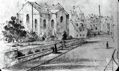
John Knox Kirk was then hidden in the angle on the right of Mounthooly. It has been converted for non-Ecclesiastical use within the last few years and enjoys a grand Vista as a result of new Roundabouts. Note Corporation economy of a Street also Lampost serving as a Bus Stop. John Knox Church (800-seats) was Built at Mounthooly, Aberdeen during the Church extension movement in the early 19thC, finished in 1835. The 1st Minister was the Reverend Alexander Philip, a native Aberdonian, as was the 2nd Minister, the Rev John Stephen, inducted in 1838. However, he came out with most of his Congregation at the Disruption in 1843, to form John Knox Free Church (1,000 seats) in nearby Gerrard Street. The Parish of John Knox was disjoined from those of Greyfriars, St Nicholas & St Machar as a quoad sacra Parish in 1880. The Minister at the time was Herbert Bell (1842 – 1887), a popular Preacher and instrumental in greatly increasing the size of the Congregation.

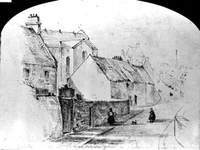
1 – John Knox Old Church, Mounthooly These drawings by Andrew Gibb Jr show the old Church. It was built as an extension Church in the Parish of Greyfriars. Building commenced in 1833 and finished in 1835 it was more visible in this era, and had a Boys & Girls School at its Rear. The Artists viewpoint is from the North-west side of the Canal Bridge later the GNSR Railway Line ran beneath it. Beyond at the Mounthooly Road end are the houses at the Gallowgate Head to the Left were Drying Greens which lay between the Spital Road and the Church Graveyard. The House at the front may have been the Manse in view of the Arched Windows. Demolition of the old Church & Construction of its replacement began in 1910. A larger building was needed to accommodate an expanding Congregation. Alexander Gammie, in his Churches of Aberdeen (1909), credits the increase in attendance to the popularity of Rev. George A Johnston, who served as the Church’s Minister from 27th September 1905 to 1909.
2 – John Knox Old Church, Mounthooly – Beyond at the Mounthooly Road end is higher density housing by West North Street, to the Left is more of a Garden with trees or Drying Greens which lay between Mounthooly (leading to the Spital Road) and the Church Graveyard. This image likely dates from the late 19thC.
3 – John Knox Old Church Mounthooly, Artists viewpoint is just short of the Canal Bridge, later the Railway Line ran beneath it. Beyond at the Mounthooly Road end are higher density houses by West North Street and McKinnon’s Foundry Chimney Stack, and to the Left are more Church obscuring houses which lay between the Mounthooly Road (leading to the Spital Road) and the Church Graveyard
The congregation of John Knox Church was composed almost entirely of the Working Classes, and the Church is situated in what is practically an East-end District. Yet it had not been lacking in the enterprise & ability to undertake & complete important Schemes solely by its own efforts. The erection of a Church Hall, the introduction of a Pipe Organ, and the erection of a hand-some new oak Pulpit are instances of what it achieved.

The Sunday School grew so large that a new Church Hall had to be built in 1885. Though Herbert Bell died young (in tragic circumstances at Kittybrewster Station in Aberdeen), his successor, Henry Ranken, was of the same energetic type and the Congregation continued to grow. After a few short but successful Ministries another powerful Preacher, George A Johnston, was appointed in 1905, and the Congregation was further augmented. A New Church Building in local Grey Granite was built in 1911. In 1987, the former John Knox (Gerrard Street) Free, United Free, Church of Scotland Closed and the Congregation United with John Knox, Mounthooly. The Congregation United again with the new Greyfriars Church, in Broad Street, in 1997. The Architectural drawing of John Knox Parish Church from 1910 replaced an older Church Building on the same Site. As indicated at the bottom of the Image, the building was designed by the Wilsons & Walker Architectural Practice. Demolition and Construction was began in 1910 and completed the following year. Funding for the New Church was raised by the Church Congregation. This included holding a Bazaar in the Music Hall on 6th, 7th & 8th October 1910. The new 1911 Building was converted into Flats.
William Fiddes & Son, Wood Merchants & Packing Box Manufacturers, Mounthooly Sawmills. Telephone No.470; (h Hazelbank, Kittybrewster) c.1892.
