Ruthrieston or Pot Burn
From the Foul Moors (Beechill & Auchinyell) to the Packhorse Bridge
Ruthrieston or Rudrystoun means Roderick’s Town, coming from “Ruadri,” the Gaelic for Roderick.
Ruadri’s Mound (Motte & Bailie Castle) – Ruadri was a 12thC Warlord & Strongman who declared his Estate and made his Citadel on this Strategic Site – he was the so-called last Mormaer (tribal Chieftain), and 1st Earl of Mar. Raising himself up to the heights of his Commanding Motte he could look down upon his Peasants, Land-Slaves whom he would have Bonded to the Fertile Earth in the broad flat Fertile Valley of the Ruthrieston Burn below. Also, Ruadri’s Stronghold – (the remnant of his Castle was still in evidence until about 100-yrs ago, at what is now the Southside of Ruthrieston Circle) -would have Commanded the Fords O’ Dee Crossing Point (the only reliable Ford on the Dee East of Park) where he could have Demanded Tribute from all Crossing the River to and from the Causey Mounth – the only Road over the Mounth (Hilly Upland) which isolates the Dee Valley from Lands to the South.
This Burn has 2-Branches, the East & the West. The East rises at Beech-Hill & Flows 1st North-east and then South-east along the Southside of the Countesswells Road to Mannofield. Though it runs undercover now its Course can easily be seen in a Hollow within 100-yds of the Road. It forms the Boundary between Old Machar & Banchory-Devenick, the Municipal & the Parliamentary Boundary between the City & the County of Aberdeen. At 1st, it is the Northern Boundary of Springbank Cemetery; but the Entrance Gate is Across the Boundary and within the City. Crossing Great Western Road it holds on in the Line of Countesswells Road to Newlands Cottage on Broomhill Road. On the South-side of the Road, there is a small Enclosure within which there is a Filtering Bed for Water to feed the Ponds in Duthie Park, which is taken-off there. The Burn crosses the Deeside Railway and takes a straight Course to the Old Bridge on the Hardgate, near the River. The lower part of the Course is covered up, but the Parapet of a Bridge shows where the Burn crosses Holburn Street. The West Branch comes from Auchinyell, on the South-side of the Railway. At 1st, its Course is Open, but the Lower half is covered up. It crosses Holburn Street and passes through a Boating & Skating Pond near the River Dee and then joins the East Branch at the old Packhorse Bridge on the Hardgate. Below the Bridge, the Ruthrieston Burn enters the Dee.
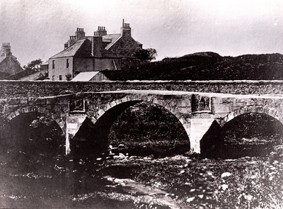
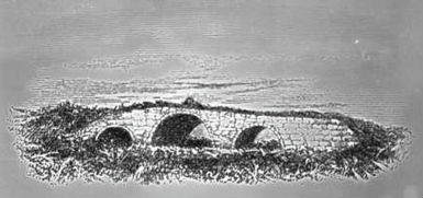
Ruthrieston Packhorse Bridge
The Opening of the Bridge of Dee in 1527 diverted the Ancient Causey Mounth Road across it, where it then turned Eastwards along the North Bank of the Dee to cross the Ruthrieston Burn.
Originally known as the Pot Burn the Ruthrieston Burn is a small Stream, but it needed Fording and in Spate from the influx of the Dee and its separate Channels could prove troublesome.
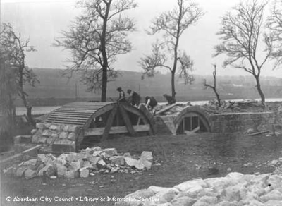
In 1693 the Wooden Bridge over the Burn was replaced by a Stone-built narrow 3-Arched Bridge of ‘Aistler-wark’ – a Packbridge built with low Parapets, thus enabling Pack-horses to Cross with their Side-bags or Panniers without difficulty.
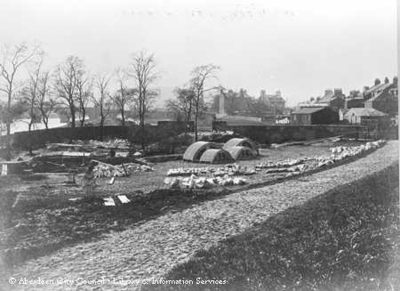
The Bridge was moved 30M Eastwards to an adjacent Site on Riverside Drive in 1923. It was Rebuilt with Parapets thus destroying its original unique & purposeful character.
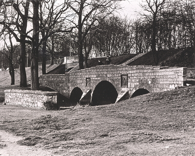
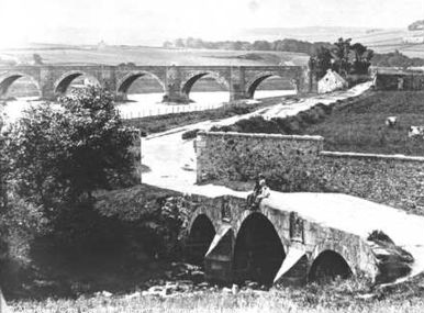
The Pack Bridge – on the Riverside Drive leading to the Old Bridge of Dee
An old Stone Bridge with low Parapets dating from 1693. It once carried the Main Road into Aberdeen from the Brig o’ Dee and has since been reconstructed near to its original position. (formerly known as the Ruthrieston Bridge) it was dismantled, moved & rebuilt 30M Eastwards to Riverside Drive in 1923. Ruthrieston Pack Bridge, is the only surviving example of a Packhorse Bridge in this area of Scotland, was described by Librarian G M Fraser as an “exceedingly well-built Bridge, of dressed Granite“. It would appear that the Bridge was 1st mentioned in the Town Council Minutes in 1541 as the “Blind Bryg”, however, but what Quarry in the Hill of Pitfoddels over 150-yrs later. Despite being moved in 1923, Ruthrieston Pack Bridge survives in good condition. The Parapet above is a later addition, the original Parapets being long gone even in 1910.
The main Loss is the weathering of the 2-Coats of Arms. That to the Left is of Aberdeen City, with 3-Towers supported by 2-Leopards, and the motto “Bon Accord“; while the one to the right belongs to Robert Cruickshank of Banchory (Devenick), who was Provost at the time the Bridge was built and added his Coat of Arms without the Council’s permission. In 1698 when he ceased to be Provost the Council demanded the Stone be removed and that Cruickshank should pay for a new Stone, on which would be a Latin Inscription. When Cruickshank refused to pay his Stone was turned around and the Inscription carved on the reverse side. It was not until the Bridge was repaired in 1877 that the Stone was turned back to display the Coat of Arms. In 1796, the Southbound Road layout changed and Traffic was diverted away from the Ruthrieston Bridge.
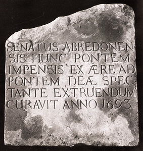
Latin Inscription on the Stone of Ruthrieston Bridge. It reads “Senatus Abredonensis hunc pontem impensis ex aere ad pontem deae spectante extruendum curavit anno 1693” (“The Town Council of Aberdeen caused this Bridge to be built with Moneys from the Bridge of Dee Fund in the year 1693“).

Ruthven House is illustrated in James Forbes Beattie’s 1875 Feuing Plan of the Ruthrieston Estate (see Brogden), but predates this by at least 10-yrs. The House is of unusual design, with Balconies Linking the advanced outer Bays at 1st Floor & Attic. The Building has been demolished. Once the House John Humphrey Shipbuilder c.1875

Mid 19thC. 2-Storey & Attic, 3-Bay Colonial style Villa with later replacement Pavilion Wings. Painted smooth render to principal Elevation; wet-dash render to sides & rear.
SE (Entrance) Elevation: 3-Bay; outer Bays advanced with full-height canted windows; canted Dormers above. Central Bay advanced at ground; tripartite doorway with bracketed cornice over; timber panelled door with leaded stained glass (c.1900) to upper panels; stained glass to side windows & fanlight. Latticed Balustrade to Balcony above; single window at 1st-Floor; timber brackets to Attic Balcony. Single-Storey lean-to Pavilions to outer left & right, altered in early 20thC.
NE & SW Elevation: lean-to Pavilion at Ground; 2 single windows to outer left & right at 1st-Floor.
NW (Rear) ELEVATION: not seen 1993.
2-pane sash and case windows to Street; small-pane to sides & rear. Grey Slate Roof; overhanging Eaves; Stone coping to Gables; Coped Gablehead Stacks; moulded Octagonal Cans.
Interior: plain plaster Cornices; panelled Doors; timber Handrail & Balusters to Stair; 2-Timber Chimney Pieces at 1st-Floor.
Gateopiers & Boundary Wall: Brick-coped rubble Boundary Wall to street; Pyrimidal Caps to Pedestrian & Carriage Gatepiers. 2-Storey Bothy to NE of House.
