Powis & Tile Burn
From Rosehill Quarries to River Don
Powis is a modification of the Gaelic word “poll“, a hole full of water, or a Burn. “Poll” is sometimes softened into “pow” a name given to the deep slow-running Ditches draining the Carse of Gowrie; and the name Pow Brig, occurring in the Chartulary of St Nicholas, is not a mistake for Bow Brig, though it was over the Denburn, for it was once only the Trunk of a Tree, and it means simply the Burn Bridge.
The Powis Burn rises at the Rosehill Quarries (Cairncry) and flows along Back Hilton Road, forming the Boundary of the Freedom of Aberdeen till it is met by a Tributary from Downie’s Howe, on the Northside of Ashgrove. Downie’s Howe has a place in a mysterious Tale of Slaughter said to have been committed at King’s College. In connection with this, it may be noted that Downie is here not a personal name but a corruption of a Gaelic word, “Dunan,” meaning small Hill or slightly rising Ground. After the Junction, the Burn flows, below Ground, along the Southside of Central Park and crosses Great Northern Road at Powis Terrace, where it runs open for a few yards. It passes under Kittybrewster Station, and there, before the formation of the Railway, it was joined by a short Tributary from the Railway Bridge at the Northend of Berryden. George Taylor’s Map in 1773 shows between the 2-Burns Kettybrewster’s Howe, with a House and its Well. This name had been given in the belief that in or near the Howe there had once lived a woman named Ketty, who Brewed Ale for Sale. Tales, wholly fictitious, were founded on this assumption; but the name means small broken Fold. It had been given to a Fold for cows, formed by planting upright in the ground Tree-trunks close enough to prevent the Cattle from getting through. Such Folds were sometimes lined outside with skins of cattle & sheep for protection against inclement Weather. When a Fold fell into decay and could no longer keep in Cattle it was sometimes abandoned and was then called a Broken Fold. Kettybrewster is a corruption of the 2 Gaelic words “Cuitan,” a Small Fold, and “Brisde, – “broken”. “An” at the end of a name in Gaelic usually became “y” or “ie” in passing into Scotch, hence “Cuitan” had become “Cuity” and this had lapsed into Ketty. There was Anciently in Aberdeen another Fold of the same name at a Well at a Bend in Froghall Road, near the March between the Lands belonging to the Town & those of St Peter’s Hospital. There was also a Fold of the same name in Keig at a Well, but the name had been corrupted into Kittythirst. One of the March Stones of the Freedom of the City, which was in the Den at Kittybrewster, is missing. Its Site was on the Westside of Powis Terrace, opposite Kittybrewster Railway Station Gate. Crossing the Railway the Powis Burn runs Underground on the Southside of Powis House.
At the Hollow, it is joined by the Loch Burn, which is first seen near Hilton Lodge, on the Westside of Clifton Road. It crosses Woodside and the Railway, Underground, and it then comes to light flowing East along the lowest part of the hollow. On approaching the Kettle Hills it turns South and drains the Bed of the Loch of Aberdon, called also the Bishop’s Loch because it belonged to the Bishop Officially. It crosses Boat-House Brae, drains the hollow below Powis House and joins Powis Burn, which then crosses Bedford Road. It flows around the Base of what is called Broomhill in Gordon’s Map of 1661 but now Hermitage Hill, though the supposed Hermitage on the Top is only a Summer-house Built there to have a good Outlook Seaward.

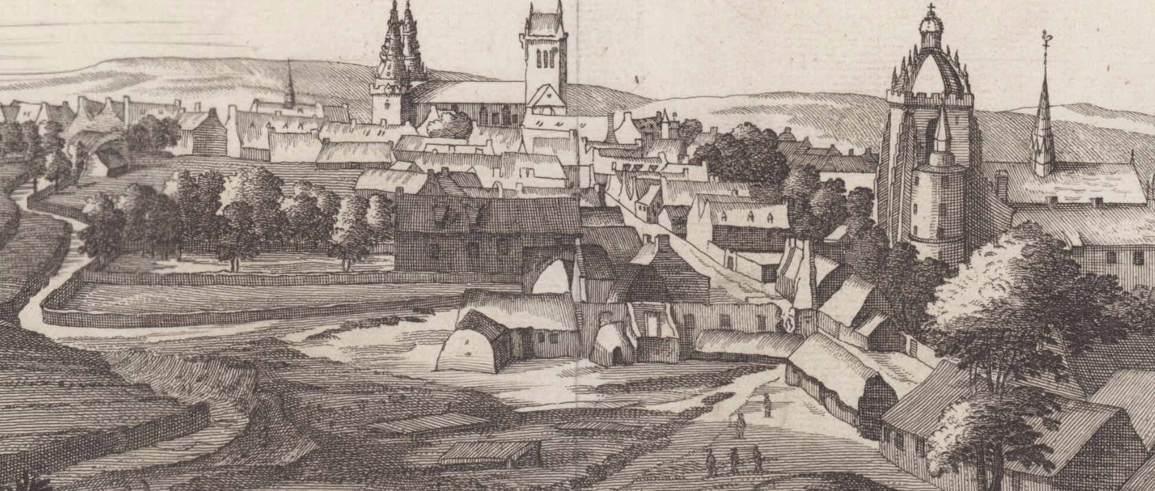
James Gordon – Map of Aberdeen 1661
On the right, a small Addition comes in from the Firhill Well, once much resorted to in Summer on Sunday morning Jaunts, but since moved & quite forsaken. Till about 1770, its Course was through a Quagmire and it was from the Pools & Holes through which it flowed that it had got its name. It formed the South Boundary of Aberdon and on the Southside of it stood the Snow Church. As it was the only available Water Supply for the Southside of Old Aberdeen and the Northend of the Spital the Town Council of Old Aberdeen forbade Washing in the Burn above the Powis Bridge where it crossed the Road. It now Flows Underground across the Street and through the Corner of the University Grounds. Keeping nearly in the Line of University Road it reaches King Street, where there is a Bridge though it is not readily discernible. Crossing King Street it drove a Sawmill, formerly a Meal Mill, (Lady Mill) the only Work that the Burn does. After crossing King Street, Powis Burn becomes the Tile Burn, because it passes the Site of Seaton Brick Works where Roof Tiles used to be made for the Houses in Old Aberdeen. Near the end of its Course the Tile Burn turns North, but before entering the Don it was joined by the Banstickle Burn, on the Right, from the Canny Sweet Pots.
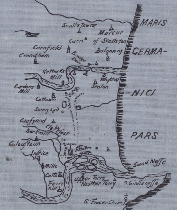
Tile Burn & Donmouth Map
Powis Burn Bridges
The Old Road from the North to Aberdeen came down Clifton Road, but near the bottom of the Brae it bent to the West and crossed Central Park. It crossed the Powis Burn at the Eastside of the Park at a place called Kingsford. This name is not derived from the English word King but from the Gaelic word “Ceann” meaning Head, and the name means a place at the End of a Ford. There was another Ford on the Tributary of the Powis Burn which came from the Loch of Old Aberdeen, but when the Loch was drained a Bridge took the place of the Ford. It was at the Aloitar Hole at the bottom of Boat-house Brae, and it was one of the Stations where Custom Duty was Collected on St Luke’s Fair days. A Bridge over the Powis Burn in College Bounds is mentioned in 1531 in Bishop Gavin Dunbar’s “Kew Foundation of King’s College” in “Fasti Aberdonenses.” The Powis Burn separated the College Garden from the University Buildings. This Bridge is mentioned in 1665 as being one of the Custom Stations on Fair Days. The Burn was the Water Supply of High Street, College Bounds, and the Northend of the Spital, and in 1689 the Town Council issued an Ordinance forbidding Washing in Powis Burn above the Bridge. It is shown in Gordon’s Chart of Aberdeen, 1661. The Bridge required Repair in 1697 and the Members of the College presented a Petition to the Kirk Session requesting that Stones of the Kirk which had fallen and were lying in the Kirkyard should be given for repairing the Bridge. The Petition was Granted, the Session “knowing the usefulness of that Bridge and the same lyk to go to Ruine unless speedily repaired.” When the last Bridge over the Burn was Erected the Cost was defrayed from the Bridge of Don Fund, but this Bridge was removed when the Burn was covered up through the University Grounds. The Foundations of the Bridge were laid bare in 1906 in the course of some Sewage Operations where the Burn crosses College Bounds. Keeping nearly in the Line of University Road it reaches King Street, where there is a Bridge though it is not readily discernible. When King Street was formed a Bridge was made over the Burn at Lady Mill. A Parapet on the Westside of the Road marks its position. Near Seaton Brick & Tile Works it was Crossed by the Tile Ford, which was on the Road from the Brickwork to the Sand Hills or, Seaside, where the Sand required in Brick-making was dug. A Wooden Bridge had taken the place of the Ford. Near the end of its Course, the Tile Burn turns North, but before entering the Don it was joined by the Banstickle Burn, on the Right, from the Canny Sweet Pots. The Tide comes up the Tile Burn and Boats & Small Ships could take in Cargoes of Tiles & Bricks very near the Spot where they were made.
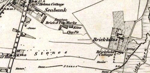
Ordinance Survey Map 1842
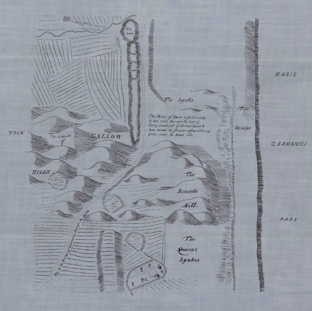
The queer name, Canny Sweet Pots, given to Pools of Freshwater at the Head of the Banstickie Burn, which was a Branch of the Tile Burn and within a ¼-mile of the Sea, conveys no meaning to an Englishman’s ear; but to a Highlandman the name suggests that there was a primitive Settlement of Fisher People on the Burn, who were supplied with Water from Deep Pools at its Source. The name seems to be a compound of the Gaelic words “Ceann,” Head; “na,” of the; “Suidhe,” Settlement or Residence, either temporary or permanent; and the Scotch word “Pots,” meaning Deep Pools of Water. We may infer from the name that here Landward people came in Winter when food grew scarce in the Interior, or that there was here a permanent Hamlet of Fisher People. On Parson Gordon’s sub-Map, 1661, there is Printed beside the Canny Sweet Pots:- “The River of Done is said credibly to have runn through the Loch of Canny Sweets Pott of Old and thence to have turned the Streame Eastward, entering the Sea under the Broad Hill.” The nature of the Ground – Red Laminated Clay – renders this extremely unlikely. Formerly at High Water of Equinoctial Spring Tides the Sea covered a large area at the Mouth of the Tile Burn, but it did not go far up the Banstickle Burn. A Fisher Village at Canny Sweet Pots would have had a good claim to be called Aberdon.
Seaton Brick Works
The Red Laminated Clay at Seaton Brick Works is derived from the Old Red Sandstone Beds that once existed, on a larger Scale than they do now, between the Dee & the Don on the Site of the City. In the Glacial Epoch, the Snow Sheet entering the Sea between the Rivers abraded and carried off the Soft Red Rocks. As it entered the Sea it melted, and its burden of Debris was taken in hand by the Waves. Big boulders and large Stones had been left where they fell out of the Melting Ice; small Stones had been rolled backwards & forwards at the edge of the Sea till worn to Pebbles & Sand ; the Sand from the Rough Clay licked up by the Ice had been well washed and deposited in Layers on a sloping Beach; and the Washing’s, fine pure Clay, had been carried out into Deep Water, where it Sank when the Tide was at rest at High & Low Water. When the Tide was running fast, flowing or ebbing, the Light Clay did not get time to fall, but only a little heavy Sand. Eight Layers had been laid down every day, 4 of Clay when the Tide was standing still alternating with 4 of Sand when it was running North or South. When a spadeful of this Clay is dug out of a Bed and dries in the Sun it splits up at the sandy layers into thin Leaves or Laminate. Since its deposition, the Land had risen far enough to raise the Clay Beds above the Sea, though in some Clay Pits the Laminated Clay goes down below Sea Level.
Aulton is the Gaelic word for a Stream, coupled to that for a Farm or Hamlet. Like Auldearn, means the Water of Erin, or Oldwhat, which means a slow flowing Stream, Altquhat. It was the lack of understanding amongst Map-makers who only knew English & Lallans, that gave us Old Aberdeen. The Stream and wee Loch & Boggy Ground was Aulton. The Stream went on towards where King Street is and powered a Mill across the Road from where now University Road meets King Street. Hence why our Grandparents called that part of King Street. “Lady Mill.” – the Loch was long gone by the time I lived in College Bounds in 1942. We did have giant mushrooms growing out of the Floor under the Bed, pushing against the Mattress. So I guess the Bog still existed under the House. We were on the Ground Floor – Fraser H.
Map Showing Burns & Mills
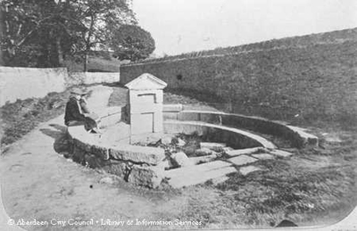
Lady Mill
In 1832, after the New Bridge of Don was Built, a Meal Mill was erected on the Powis or Tile Burn on the Eastside of King Street. It continued to work till Flour became as cheap as Meal. Bread almost entirely ceased to be made from Oatmeal, and many once prosperous Meal Mills have been given up. Among these was Lady Mill – so named from Lady Bruce, wife of Sir Michael Bruce. It was later converted into a Saw Mill. During the latter half of the 19thC, many large Meal Mills have been erected within the City of Aberdeen. The Northern Co-operative Company’s Mill at Millbank, Berryden Road, ground Oats for local consumption and supplies its own Sale Shops. The others dispose of their Meal in Bulk, and most of it is Exported to England – for Horses.
Oatmeal: A Grain, which in England is generally given to Horses, but in Scotland supports the People. Dr Samuel Johnson Lexicographer & Harmless Drudge –
Johnson: In England, we wouldn’t think of eating Oats. We only feed them to Horses.
Boswell: “Well, maybe that’s why in England you have better Horses, and in Scotland, we have better Men“.
