Loch of Aberdene & Its Feeders

At one Period during the 13thC, and, perhaps, part of the 14thC, the Loch must have been a beautiful Sheet of Water, often “White wi’ Geese and Grey wi’ Gu’s,” but not for many years before Gordon’s description of it. Before then it had become “a large Fenny Marrish Commonlie called the Loch, a Fenne, or Pudle rather.” The Outlet was at Gilcomston Steps. It was a Shallow Basin excavated by a Glacier from the Westburn Valley, augmented by a smaller Glacier from Berryden, and it had been Deepest where it was Narrowest, at the North end. When making a Sewer in Hutcheon Street Peat-Moss containing stems of Hazel was found near the Gate of Broadford Works, showing that it had been Deep there.
Litsters (or Dyers) such as Adam of Spens (1447) and John Litster, who in 1498 was living in the Green next door to the Carmelite Friary, had a serious impact on the Town’s Water Supply. Statutes dating from the 15thC onwards show that both the Loch and the common Rivulets in the Town were heavily polluted by the various Craftsmen Washing their own Produce. A Statute of 1507 mentions that the Gutters which ran to and from their Workhouses ought to be closed as they were having a serious impact on the Town’s Water Supply. It was also stipulated that the Litsters should only Wash their Cloths in the Burn that passed from the West end of the Loch from the Loch to the Denburn. It is possible too that the Aberdeen Crafts produced similar problems to those in London where there were complaints of Foundations being rotted by the large amount of Wastewater produced through the repeated Washing of Cloth. On 9th October 1496, Red Cloth was singled out for Polluting the Water Supply. Interestingly, 2-Types of Red Dye have been identified in Cloth remains from Medieval Aberdeen; one is from the Plant Madder, which can produce a Brick Red; and the other from the Insect Kermes. Both Dyes, if used in Aberdeen, would have been imported with the Kermes coming from the Mediterranean where it lives on the Branches of a Species of Oak Tree. In 1496 the Baxter’s (Bakers) among other Crafts were said to be causing Pollution in the Loch & the Town’s Water Supply.
In 1512, the Council decreed that Waulkers (or Fullers) whose job it was to Cleanse & Thicken the Cloth should not hang it to dry over the Walls of St Nicholas Church or within the Kirkyard. Fullers, like Dyers & Tanners, seem to have Worked near the Loch, using the Water & Polluting it in the process. Amongst them, perhaps, John Broune in 1455 & Robert Swyntone in 1492. There is no direct Archaeological evidence of the Locations where Fullers Operated, but many of the pieces of Fulled Medieval Cloth found on Excavations in Aberdeen must have been through their hands.
His coat an’ breeks war’ o’ a lichtly blue Weel waukit, an’ the pick o’ hame-grown woo‘.
Walk-Mill, Waulk-mill. A Fulling Mill
Fulling or Tucking or Walking (“Waulking” in Scotland) is a step in Woollen Cloth Making which involves the Cleansing of Cloth (particularly Wool) to eliminate oils, dirt & other impurities & making it thicker. The Worker who does the job is a Fuller, Tucker, or Walker. The Welsh word for a Fulling Mill is Pandy. This is used in several place-names. Fulling involves 2-Processes – Scouring & Milling (thickening). These are followed by Stretching the Cloth on great Frames known as Tenters and held onto those frames by Tenterhooks. It is from this process that we derive the phrase ‘being on tenterhooks‘ as meaning to be held in suspense. The area where the Tenters were erected was known as a Tenter-ground. Originally, this was literally Pounding the Cloth with the Fuller’s Feet (whence the description of them as ‘Walkers’), or Hands, or a Club. From the Medieval Period, however, it often was carried out in a Water Mill. Fulling Mills – from the Medieval Period, the Fulling of Cloth often was undertaken in a Water Mill, known as a Fulling Mill, a Walk Mill, or a Tuck Mill. In these, the Cloth was beaten with Wooden Hammers, known as Fulling Stocks. Fulling Stocks were of 2 kinds, Falling Stocks (operating vertically) that were used only for scouring & driving or Hanging Stocks. In both cases, the Machinery was operated by Cams on the Shaft of a Waterwheel or on a Tappet Wheel, which lifted the Hammer. Driving Stocks were pivoted so that the ‘Foot‘ (the head of the Hammer) struck the cloth almost horizontally. The Stock had a Tub holding the Liquor & Cloth. This was somewhat rounded on the side away from the Hammer, so that the Cloth gradually turned, ensuring that all parts of it were Milled evenly. However, the Cloth was taken out about every 2-hrs to undo plaits & wrinkles. The ‘Foot’ was approximately triangular in shape, with notches to assist the turning of the Cloth.
A Waulk Mill or ‘wak mil’ . (Wauk Milling – also written waulk, walk, wack or wak – is the process of soaking, beating & shrinking Cloth to make it thick & felted. It gives rise to the Family name Walker.) Waulker, a Fuller of Cloth
The basic understanding of Medieval Wauk Mills in that: there is a Lade (a Pool, Trough or some other kind of Reservoir) with a built entrance; there is normally a small Building on the Lade and a perimeter retaining Wall; there are possible points at which a Water Wheel could be Sited & Water Flow managed; and which could serve as a Pool for soaking Cloth. The process was performed by hand in the Hebrides until fairly recently to the accompaniment of Rhythmic Gaelic Songs to coordinate the movements of the Waulking Team.
Waulking-board, a long grooved board on which cloth is waulked.
Waulking-frame, a frame, orig. of wicker-work, on which cloth was laid to be waulked.
Waulkin-mill, a fulling Mill, a Mill in which cloth is shrunk.
Waulking-song, any (Gaelic) song sung by a team of women engaged in waulking, gen. one of which the Rhythm suits the motions involved, different Songs being used for different Stages in the Process.
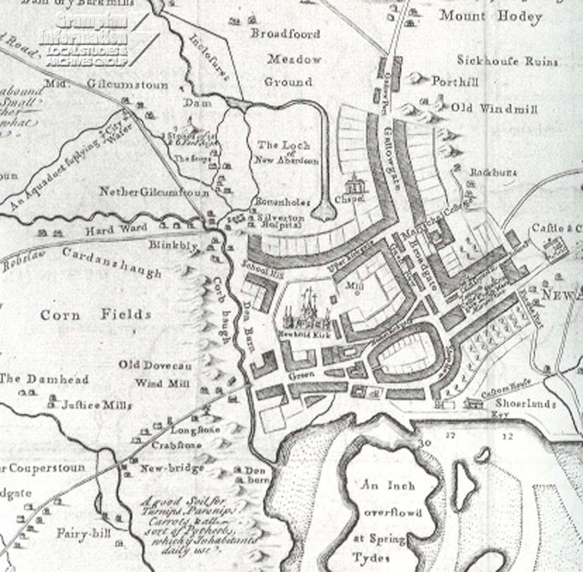
The Magistrates ordered the Loch to be Dried in 1603, to make it of more Value to the Town as Pasture, “to remain in all tyme vnlaborit or manvrit; to grow Grass and to serve onlie for that vse, and to furnish Water to the Town which serveth three Milns and the Posterns nearest to it.” This was to be done “be the sicht and advyce of David Anderson the Townis Maister of Wark, the hail trinck of Water sal be drawn down the South syd of the Lochfield Croft and to rin at the West syd of the Gallowgate, and Eist syd of the said Loch, in the auld trinck, to be cassin deper and wyder.” The Ditch at the South-west side nearest the Woolmanhill, was to be closed up. The improvement effected must have been very inconsiderable, as there is still Gordon’s Picture nearly 60-yrs after, “a fenne, or pudle rather.”  James Gordon – Map of Aberdeen 1661
The Loch appears to have Anciently supplied Water for Domestic purposes. In process of time, however, it became unfit for such uses. In 1632 the Municipal Authorities declared – “considering the great necessity wherein the neighbours of the Town stood through want of pure & clean Water to serve their Houses and that the most part of the Water wherewith they were served, coming only from the Loch, was Filthily Defiled & Corrupted, not only by the Gutters daily running into the Burn, but also by Litsters [Dyers], and the Washing of Clothes, and the abusing of the Water in sundry parts, with other sorts of uncleanness,” They came to the resolution that Fountains should be erected at the Public Expense for a proper Supply of Potable Water.
At a time Antecedent to the commencement of the Extant Records of Aberden there was within the area of Modern Aberdeen, but outside the Ancient City, a huge Sheet of Water called the Loch, covering an area of more than a 100-acres. The North end extended along Fraser Eoad to Millbank Lane and thence to the lowest parts of Holland Street, where its Chief Feeder, the Westburn, entered; but the main portion of the Loch was south of Hutcheon Street. It was bounded by the high ground at Kingsland Place, Maberly Street, Spring Garden, Loch Street, Crooked Lane, St Andrew Street, Blackfriars Street, the Railway and the High Ground East of Ann Street. The Outlet was at Gilcomston Steps. It was a shallow Basin excavated by a Glacier from Westburn Valley, augmented by a smaller one from Berryden, and it had been deepest where it was narrowest, at the North end. In making a Sewer in Hutcheon Street Peat-moss containing stems of Hazel was found near the Gate of Broadford Works, showing that it had been Deep there.
The Loch to the then North of Aberdeen was fed by Burns flowing in from the North & West and was the Burgh’s main source of Fresh Water; it also supplied 3 of the Burgh’s many Water Mills, such as the Upper Mill at Flourmill Brae. Evidently more Water was being Abstracted from the Loch than Drained into it, because Parson Gordon depicts it as ‘the Marsh formerly known as the Loch’. By 1800, the Loch had shrunk to about the area now covered by Loch Street, and by 1838 it had disappeared completely. The area now known as the Lochlands became George Street, Charlotte Street, St Andrew Street & John Street.
Before we hear of the Loch its 2-Feeders the Westburn & the Spital Burn had been cut off to Supply the Town with Water and to Drive the Upper Mill at the Southend of the Guestrow; and, as there were no Springs of Water in its Bed, it had to depend on the Rainfall for its Existence. Under these circumstances it must have varied much in size according to the Season of the Year, being large in Winter & confined to Deep Pools in Summer. We 1st hear of the Loch from Spalding, who wrote an Account of the Troubles of Aberdon & Aberden – or, as he calls them, both Aberdeins – in the Covenanting Times in the Reign of Charles I. These Troubles, he says, might have been foreseen by the inhabitants if they had not been blind to the augury of the Sea Maws or Black-headed gulls, which had begun to forsake their usual Breeding Haunts in the Lochs of Aberdon & Aberden. The latter was evidently Drying up, and its Bed was becoming clothed with Grass for Grazing. Soon after Spalding’s Lament for the Gulls, the Town’s Records say:— “The Magistrates, considering the Prejudice done to the Grass of the Loch by the dailie resorting of the Geiss belonging to sindrie of the Inhabitants, ordained the Belman to be presentlie sent throw the Town charging all the Inhabitants to remove their Geiss out of the said Loch.”
Spital or Froghall Burn
Spital is a name derived from a Hospital for Infirm Priests, Founded before 1200 by Bishop Matthew. It was dedicated to St Peter, and it stood in what is now St Peter’s Cemetery on the Eastside of the Street called Spital; but the Burn was at the Base of Spital Hill on the Westside. Froghall is an old name coming from the Gaelic word “Frog,”a hole full of Water; and there must have been one on its Course anciently about Jute Street. In Foveran there is a place called Frogmore from a Big Pool near it. The Spital Burn formed the West Boundary of a small Parish called St Peter’s or the Spital, suppressed at the Reformation. From Jute Street downwards to the Denburn it had been part of the Boundary between the Parishes of Old Machar & St Nicholas; but it has now vanished entirely out of sight. It rose out of the Ground at the Embankment in Sunnyside Road, which now covers its Well-Spring. Formerly, it passed under the Aberdeenshire Canal, the Bed of which the Railway now occupies; but originally it crossed the Line of the Canal and entered on Causewayend at the Boundary of the Royalty, at the end of a House on which the word Causewayend was painted. This is at the Lowest part of the Street, where there was anciently a Ford across the Burn. Causewayend means the end of the made Road which began at the Gallowgate and extended to the City Boundary. Beyond this the Road had long been left in its natural State. A Causeyed Road might be paved or shod with Stones laid close & level by hand, or with small Field Stones & Gravel laid down promiscuously. Both ways were practised by the Romans in this Country, as is seen in their Roads along the Roman Wall. There is a Causewayend on the Northside of the Don ; and “Causeway,” both in it and in the Aberdeen Street, and also “Calsay” in the name Calsayseat and “Causey” in Causey of the Cowie Mounth mean a shoeing of small stones laid down at random & covered with sand or gravel. Only the middle part of such roads was Shod; there were at the sides broad bare strips called the Ridges. “Causey” comes from Latin “calciare,” to shoe, through French “chausser,” having the same meaning. The Burn crossed Causewayend and formed the Boundary between the Feus in Charles Street & Hutcheon Street, and it crossed George Street at No 466, where there is a low place in the Street, now much made up. Here then used to be a Petty Customs Box where a Tax was paid on Provisions entering the Town. West of George Street it received the Westburn and turned South. It crossed Hutcheon Street at the West Side of the Meat Market, entering the Loch at its North-east Corner.
But looking on a Plan of the Town in the present day, the extent of Ground covered by the Loch will be better understood, and the change that has taken place more strongly contrasted with that of 1661. Many are the Orders given by the Magistrates for Cleaning the Loch, from the 14th to the 17thC. Parson Gordons Map of 1661 showing the extent of the ‘Marsh’ called the Loch and the Clarkseat Estate (West)Burn that skirted it’s Westside to feed the Meal Mills. ‘b-b’ indicates the Lane called the ‘Vennel‘ which gave Residents in the Gallowgate access to Water. Loch Street is defined by the Route behind the Backlands on the West side of the Gallowgate that linked to the Vennel. Evidently, even then more Water was being Abstracted from the Loch than that which drained into it.
In Gordon’s Map, 1661, we see the Loch greatly reduced in size. It does not now go so far North as Maberly Street, and it is called a Marisch. The cause is seen in a Ditch going around it on the North preventing Water from entering, and another deeper Ditch on the South draining the Loch. Taylor’s Map of 1773, shows the Bed of the Loch as Dry Ground called the Lochlands, drained by a Ditch from Innes Street to the Outlet at Spa Street, with a Branch from Gordon’s Hospital going North to the Main Ditch. The name Loch had been already, in 1661, transferred to a Mill Dam extending along the Side of the East Arm of Loch Street. The whole North end of the ‘Lochlands‘ extending on both Sides of George Street is marked ‘Spring Gardens‘, so that before 1773 Leeks & Cabbages were grown where once there had been the Great Loch, “gray with Geese & white with Goos,” (Gulls). A glance into the Backyards of the Houses on the area of the Loch shows that the Streets have been made up several feet, and these sunk places enable us to trace the Outline of the Loch when at its full extent, though that had been 600 or 700-yrs ago. Excavations for connecting Houses with Sewers in the Streets show that there is in the Bed of the Loch a great depth of rather fine Glacial Clay of a greenish yellow colour, almost destitute of Stones.
Westburn (Gilcomston Burn): This Burn, sometimes called Gilcomston Burn, rises at Mastrick & Flows East across the Road to Cairncry Quarries. It passes Castleton and runs along the Northside of Westburn Road. It is gradually being covered up, but it still runs Open through Westburn Park. Then it disappears, running below Ground across Cornhill Road and through the Lunatic Asylum Grounds. Long ago it drove a small Bark Mill (producing Tannin for Tanners) on the Southside of the Burn and on the Westside of Berryden Road. Near it, according to Alexander Keith’s ‘View of the Diocese of Aberdeen’ (1732) there was, 200-yrs ago, a Cairn marking the Grave of Baillie Cattanach who was Killed in a Quarrel with William Leith of Barns, Premnay, in 1351.
In Skene’s “Succinct Survey of Aberdeen” 1685, Leith is said to have been Provost of Aberdeen (1351-56), and on “Lawrence,” 1 of 2-Bells presented by him to the Church of Saint Nicholas, he was styled “Praepositus,” that is Provost. The Bell which he presented Cracked, and the Inscription was put on when it was re-Cast. It was smashed to Fragments by a fall when the East Church & Spire was burned in 1874.
The Westburn crosses Berryden Road at a place indicated by an Iron Plate in the Road. Then it went under the old Northern Co-operative Company’s Bakery & under the Railway a little South of the Subway, but then it does some good in cooling Condensing Ponds at the Co-operative Bakery and the Berryden Weaving Works (Kilgour). There was at one time a Dam in Berryden, with a Mill, and this gave rise to the name Millbank. The Burn next crosses Holland Street, and the end of Millbank Lane, keeping well up, but originally it turned South and entered the Loch at its North-west corner at Holland Street. Six or 700-yrs ago, it had been diverted to the East to join the Spital Burn on the West of George Street, and, United with it, crossed Hutcheon Street. Then it skirted the Eastside of the Loch, and at Maberly Street turned East, to supply Water to the Gallowgate & Broad Street. For a time it was employed to feed a Pond at Broadford Works for Condensing Steam, but having become polluted with Sewage it was given up, and Water from the Denburn took its place. At present, it crosses Maberly Street diagonally, and it may be seen through chinks in the Pavement near the end of Charlotte Street. It then turns West, behind a Carpenter’s Shop, and flows South into a Track along which there was once an Avenue bordered with Trees.
Near the end of John Street, where the outlet of the Loch formerly was, the Burn passes under the Railway and enters on Gilcomston Steps at a Passage between 2-houses, No.s 17 & 18. The Burn still passes this way near a Lamp in the middle of the Road and runs along the Westside of Spa Street, under the Pavement now but till the middle of the 18thC it was Open, and the Doors of the Houses had Bridges before them. At that time the Well of Spa was at the Southend of Spa Street, in a low-lying place at the Corner Public House called Spa Bar, and the Burn flowed between this House and the Well. Crossing the Upper Denburn it enters the Denburn above the Collie Bridge, which took its name from the occupant of a Spirit Shop (Andrew Collie?) at the end of the Bridge, where Burghers who had taken a stroll into the Country refreshed themselves before entering the Town. The Boundary between Old Machar & St Nicholas follows the Channel of this Burn from the Denburn upward to the place where it joined the Spital Burn, thence it followed the now Extinct Spital Burn to Jute Street.
G & W Patterson’s Map of 1746 showing the later extent of the Loch ending in an eye-shaped Pool (Loch’s E’e) near the Vennel and showing the adjacent Gallowgate Backlands Route and the Spur of the Vennel still defined the extent of Loch Street which now shows old St Pauls Chapel as Built in 1721. This Loch to the North of Aberdeen was fed by the Westburn & Gilcomston Burn Flowing in from the North & West and was once the Burgh’s main Source of Fresh Water; it also supplied 3 of the Burgh’s many Meal Mills, such as that at Flourmill Brae. Emerging from the South end of the Dam called the Loch’s E’e the Mill Burn flowed along Burn Court and across Upperkirkgate to the Upper Mill in Flourmill Brae.

Alexander Milne’s Map of 1789 showing a linear & narrow Loch then much reduced from that recorded in 1661 to a mere Mill Pond for the Upper Meal Mill on Flourmill Lane – Tannery Street shown on this Map was to become George Street.
By 1800, the Loch had shrunk to about the area now covered by Loch Street, and by 1838 it had disappeared completely. The area now known as the Lochlands became George Street, Charlotte Street, St Andrew Street & John Street
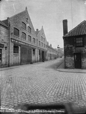
The Premises of William McKinnon & Co, Ironfounders & Engineers in Spring Garden, at its Junction with Loch Street. The Company was Founded by William McKinnon in 1798 when they did work for Local Factories. In the 1860s, they became involved in the Production of Equipment for Coffee, Cocoa, Rice & Sugar Plantations. By the 1890s, they Employed 170-men, making steam engines, boilers, sugar machinery, as well as Machines for polishing Granite. Eventually, 90% of their Manufacturing was exported; they had Agencies in 60-Countries Worldwide and they produced Catalogues in English, French & Spanish. During WW2, Production switched to Munitions Work, producing Shells, Mortars & Parts for Hercules Aero Engines. They appear to have Ceased Trading around 1992-93.
