
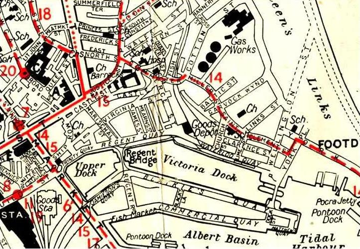
The Harbour Quays Introduction
Trinity Quay – Market Street to Shore Brae
Regents Quay – From Shore Brae to GNS Waterloo Railway Station.
Waterloo Quay – Waterloo Railway Station to Wellington Street
Pocra Quay, – Footdee
New Quay, (Lower Pocra Jetty to Abercrombie Jetty)
Jamieson’s Quay, Southside Upper Dock
Provost Blackie’s Quay – Regents Road to Dock Street
Matthews Quay, beyond Dock Street
Market Quay, – Lower Market Street (formerly Cross Quay or Upper Quay)
Commercial Quay, – Lower Market Street to Atlantic Wharf
Pacific Wharf (Commercial Quay)
Palmerston Quay, from Commercial Road to Albert Quay
Torry Quay, (Deepwater Berth on the Dee)
Maitlands Quay, (River Dee Dock – now filled in near Torry Harbour)
Point Law, (Northside)
Mearns Quay, (Southside of Point Law)
Albert Quay (South Albert Basin)
Trinity Quay – The Original Quay (from Market Street to Shore Brae)
Small Ships not drawing more than 12-ft ascended the Denburn Channel as far as Shore Brae, a road formerly much wider than now. The Quay extended from the area of Trinity Friary to James Street, it being about 200-yds in length. There was a small Creek going inward at the foot of Putachieside where Ships & Boats Lay. Such were the beginnings of the Harbour of Aberdeen. The only work of man among them was the Quay at Shore Brae. Probably it had been erected at a very early point in time. The Shiprow, which runs past the head of Shore Brae, is mentioned in a Charter of date 1281, but the Quay must have been in existence from the time that Aberdeen became a Trading Port.
The use of Coffer-dams, Piles, & Concrete in laying the Foundations of Erections in Waters had not been introduced when the Quay was Built, and its Foundation, if it had one, had been laid in the muddy bottom of the Denburn. In 1453, £53 was spent upon the Quay & in 1484 it was in a Tumbledown state. In 1512 the Quay again required Repairs & in 1526 it was seen to be a hopeless task to Build a substantial Sea Wall with the rounded ice-transported Boulders found lying on the surface of the Ground about Aberdeen. On this occasion, therefore, a new departure was made.
The Master of Shore Works of the time was sent to Dundee “to buy famous Stonis” that is, large blocks of Squared Sandstone, probably from Kingoodie, from which Stones were often brought to Aberdeen. These good Stones most likely had been used in extending the Quay Wall & not in rebuilding the old part, for in 1549 repairs were again necessary. The rise of the Tide is about 12ft on an average & more at the New & Full Moon, a Stairway was provided to facilitate Embarking & Disembarking & the Loading & Unloading of Ships. The size & draught of Ships had been increasing, & in 1561 an Ordinance was Issued by the Town Council forbidding casting out of Stone Ballast from Ships within the Flood Mark under a Penalty of 40/-. Money was constantly wanted for the Quay & part of the price obtained for the Silver Ornaments & Vessels in use in St Nicholas Church before the Reformation was laid out upon it. The continued growth of Trade necessitated Machinery for Lifting & Swinging heavy goods & a Crane was set up at the Quay-head in 1582. In 1870 the widening of Trinity Quay was ordered. This was a much-needed improvement, as the Roadway between the Houses and the Water was very Narrow. The cost of the whole work was £4,900, the greater part of which went for Paving & other purposes than the Building of the Quay Wall.

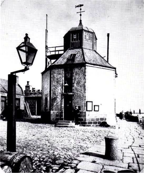
In 1885 the old, quaint-looking Weigh-House, where goods were stored to be measured & examined for Customs duties, was Demolished to furnish a Site for a New Harbour Office; but the Weigh-House because of its age was now some distance back from the original Quay, whereas the Harbour Office comes up to the same line as the other Houses. It cost £9000, which had to be paid out of Surplus Revenue. – Ach – Jist Knocket Doon
John Gibb was born near Falkirk in 1776 & only moved to Aberdeen to take up the Post of Engineer to Aberdeen Harbour in 1809. He attracted the attention of Mr Telford, by whom he was placed at Aberdeen, as Resident Engineer to the Harbour & where he undertook the Restoration of the South Pier Head, a work of Smeaton’s, which had been Destroyed in the Winter of 1807. For 6-yrs his attention was almost exclusively devoted to this Harbour, where he extended the North Pier & Built the New Breakwater on the Southside. The former of these was a work of considerable difficulty & in consequence of its exposure to the North Sea, the Eastern Point was frequently injured by Heavy Storms, which, however, only excited Mr Gibb’s energies & in 3-Seasons the Structure was completed, thus confirming the predictions of Mr Telford & himself, that the best means of deepening the access to the Docks would be, by 1st completing the Entrance & then constructing the Harbour. These Piers still remain among the best examples of that kind of Construction. During this Period he built part of the Quay Walls of the intended Docks & he 1st introduced into Scotland the Steam Dredging Machine, for increasing the Depth against the Quay Walls. In the Life of Telford, these Labours are thus noticed:- ‘Mr Gibb, with unremitting attention, Superintended every Operation connected with these difficult Works, in which he has distinguished himself by remarkable ingenuity & perseverance.’ During a temporary suspension of the Works, Gibb, with that disinterestedness & integrity which marked his character, proposed the appointment of a Superintendent, at a less Salary, Resigned his Post of Resident Engineer & turned his attention to the Execution of Works by Contract. He acquired an interest in a Quarry at Tyrebagger in 1816. His son Alexander Gibb was also a Civil Engineer & for several years they Operated from Waterloo Quay as Civil Engineers, Contractors & Stone Merchants: their early contribution to the Granite Industry was their introduction of Larger Drills for blasting holes, allowing larger Stones to be brought down in 1-Blast. In 1830 John Gibb acquired the Lease to all the Quarries on the Rubislaw Estate, which he & his Company continued to work for many years.
It was part of the Harbour Improvement scheme that the Inches should be made up far enough to be above the level of the highest Spring Tides & to shut up all Waterways between the Dee & the Harbour. Of these, there were 2, one coming in about Commerce Street & another farther West. The former took often a large quantity of the River Water when the Tide began to ebb & the Salmon Fishers had to be contended with before it could be shut up. The other was valued by the Brick-makers at Clayhill because by this method they could get Coals brought to their Works either by the Dee or by the Harbour at Spring Tides. To satisfy them the Pier was carried as far as Poynernook, with a Channel alongside. There is always in a Town where Building Operations are ongoing on a quantity of earth & rubbish to dispose of. Mr Gibb was too provident a man not to turn this to account. He saw that earth would be useful on the Inches & he made a Wooden Bridge across the Harbour at Shore Brae to let Carts pass over to the Inches. The Bridge had been easily constructed by driving Piles into the Channel & laying planks on their tops. Shore Brae was chosen because it was far up the Harbour & Market Street was not then in existence. A Bridge had been planned to be made at Marischal Street, but things were not yet ready for its Construction.
Sewers: The Harbour was the Cesspool of the Town & there were incessant complaints about the effluvium from the mud & silt when the Tide was Low. The Denburn entered the Harbour at its Upper end, near Marywell Street & the Millburn (Ferryhill Burn) entered at Dee Village, both heavily charged with Sewage. A Sewer beginning at Trinity Quay ran along Regent Quay & joining the Powcreek Burn, which had already become a Sewer, entered the Harbour at the top of Waterloo Quay. This Sewer, quite dry & not far below the Level of the Quay, was seen in 1909 in making a Track for Sewage Pipes coming down Shore Brae. In 1811, under the Powers of the Act of 1810, a Sewer was formed along the East side of Waterloo Quay to convey the Sewage from Trinity Quay & the Powcreek Burn to the lower end of Waterloo Quay, where it entered the Harbour. An outlet for Overflow in a time of rain was, however, left at the head of Waterloo Quay at the old place of Exit.
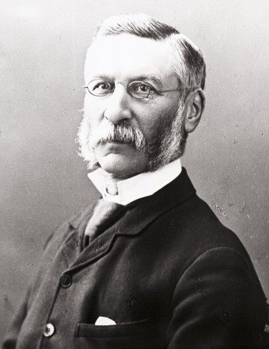
Provost Mattews Quay:
James Matthews – Architect 1810-1898 – In 1885 a new Quay was built, beginning at the South Entrance to the Dock & extending around the Point of the Inches & up the North side of Albert Basin to the then Graving Dock. It affords a convenient Wharf for Passenger Steamers, enabling them to enter & leave the Tidal Harbour without Delay. It had become a custom to name Quays after the Provosts in whose time they were Erected & the New Quay was called Provost Matthews’ Quay.
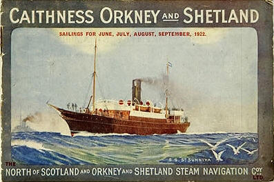
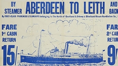
Poster for the North of Scotland & Orkney & Shetland Steam Navigation Company. Their ships sailed from Aberdeen to Orkney & Shetland from Matthews Quay. In the summer, people went on holiday to the Islands by Ship. The Company owned Hotels there. They also ran Coastal Trips to Leith & London for wealthy Travellers to visit the Highlands. Their Transport Sheds were a regular visit for Loons to look at the Pigs & Cattle held in Pens pending Transportation to the Islands. We read with much concern the notices about Swine Fever while we stuck our index fingers in the mouths of young stock to test the urgent texture of a Calf or Pigs sucking tongue. Nearby their senior animals would be defecating & urinating to our delight as we fed water & straw to them with bits of green Horse Cake or Nuts gathered from the SAI Warehouse. How we made ourselves popular with such transient Animals. The Trades Fortnight holiday period was the middle 2-weeks in July.

Matthews entered the Town Council in 1863 & retired as a Councillor in 1871. In November 1883 he was Recalled as Lord Provost & held Office until November 1886. He was mainly responsible for implementing the City Improvement Act of 1883 which included the Building of Schoolhill & Rosemount Viaduct & giving improved access to the latter area of the City. He was a Director of the North of Scotland Bank, of which he was Chairman from time to time. His Public Services (in particular the Mitchell Tower & Graduation Hall) brought an Honorary LL.D from the University of Aberdeen. In his later years, Matthews lived in some grandeur at Springhill, which he had greatly altered for himself.
The Wet Dock: One great advantage expected from a Wet dock was that the Decks of Ships would never be below nor much above the level of the Quays & that thus the discharge & loading of Cargoes would be facilitated. This belief was realised for a time, but there has been a steady increase in the dimensions of Ships & when a deeply-laden Ship has discharged part of her Cargo she rises so far above the Quay that the discharge of the remainder becomes very inconvenient. To remedy this lofty 2-Storey Sheds were now erected alongside the Regent Quay & by Steam or Electric Power goods can be lifted out of Ships & taken into the Upper Floors of the Sheds by day or by night, from which they are lowered into Carts on the Ground as required. A heavy expenditure was incurred for such Sheds on the Quays under the Act of I879.
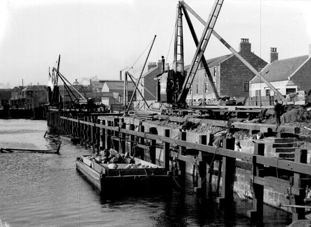
Pocra Quay Improvements using Steam Cranes
In 1888. About the same time sprang up the Importation at Aberdeen of Store Cattle from Canada. For the Accommodation of this Trade a wharf was erected at Upper Pocra Jetty in 1886 & Wooden Buildings were provided, in which to keep the Cattle for a few days and afterwards dispose of them by Auction. The Sales were patronised by Farmers from Aberdeen, Banff & Kincardine & they brought an increase in Revenue to the Harbour Board, but an apprehension arose that imported Foreign Cattle might bring into the Country infectious Cattle Diseases, which led to the Prohibition of the Importation of Live Cattle unless for Slaughter at the Port of Landing. This rendered useless the Cattle Sheds & Auction Hall at Pocra & they had to be removed.
In 1899 another Act was obtained increasing the borrowing powers to; £735,000, the additional £200,000 was needed for the following purposes mentioned in the Act:-
1. Enlargement & Reconstruction of the Graving Dock, and the Construction of a Pontoon Dock.
2. Deepening & Dredging the Navigation Channel.
3. Deepening & Dredging Albert Basin, the Tidal Harbour, Victoria Dock & the Upper Dock.
4. Widening & Reconstructing Regent Bridge.
5. Embanking & Constructing Wharves on the Dee.
6. Extension of Albert Quay on the Southside of Albert Basin.
7. Improvement of Pocra Harbour & Point Law.
8. Construction of New Quays and widening & strengthening existing Quays.
9. Erection of Goods Sheds, Workshops, and other Buildings.
10. A new Sea Lock for the Wet Dock.
11. Electric supply for power & light.
The yearly revenue of the Harbour at this time amounted to £68,000 & the ordinary expenditure to £62,000, which left a surplus of £6,000. Large sums have been spent at various times on the purchase of Ground & Buildings near the Harbour & on the reclamation of New ground & the Erection of Buildings & the Harbour Board derives a large part of its revenue from Rents of Houses & Lands.
Maitlands Quay – This overlies & probably Incorporates the Torry Harbour Timber Quay, Constructed in 1895 & extended in 1923 by the addition of a further Timber Quay. It was further extended in 1984 Westwards into the River Dee Dock area through the addition of steel sheet Piles. The Site includes the underlying remains, the integral structure & some fixtures. This Quay may overlie evidence of the Settlements of Lower Torry & Old Torry Village. At present, the Quay & the underlying Archaeology appear to be intact.
Aberdeen Harbour Admiralty Chart 1951
Aberdeen Harbour 1949

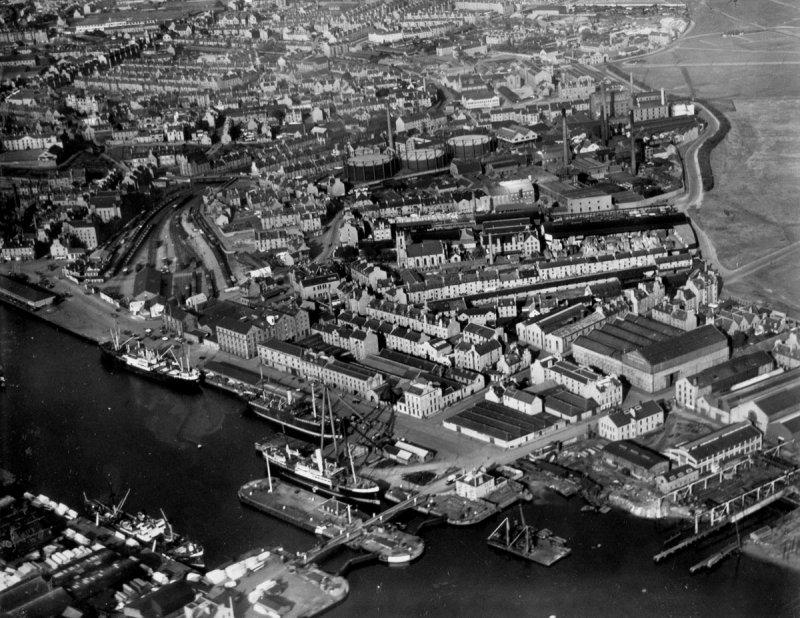
Aerial View of Harbour – with Hall Russell’s / Alexander Hall’s Shipyards lower right & the Orkney & Shetland Cargo Sheds which held Livestock & Cargo for Transportation lower Left. The SS Sunniva is Berthed on the Matthews Quayside. The old Footbridges across the Harbour from York Place are evident & St Clements Church dominates Footdee. To the left of Victoria Dock are the Robert Miller‘s Sawmills with Yards Stacked high with Sawn timber. Castle Hill Barracks with Castle Terrace Tenements in front where I lived in the Top Right Attic. The Virginia Street Steps & the Swedish Church – (yet to be) are in front of Cocky Hunters Store formerly the Old Sick Children’s Hospital. The old Waterloo Station is now a Goods Yard & Commerce Street School lies at the narrows of the Line. The 2-Storey Storage in Regents Quay with its cavernous aperture where the Editor used to play on top of the daily Cargo Loads. Marischal Street leads up to the Town House the Marischal College & the North Church. Some vast Playground zone for a wee loun tae get lost in eh. Some Target for the Luftwaffe is those Gas Tanks. Broadford Works just enter the Picture on the top left.
A closer view on the same day – showing the Harbour Gates where we louns could walk over & marvel at the huge Capstans & vertical clusters of Lever Spars then quite redundant. Baltic Street & Links Road are evident. Commerce Street leads off Wateroo Quay top left & leads to Hanover Street & Heading Hill. Bottom Centre is where we fished for Saithe in the Harbour for amusement catching the odd Eel when Fishing with a Calder’s Shop provided hook, hand line & Lead Sinker. Fish Street & Bannerman Street on opposite Sides of the Railway Line. A Pontoon Crane Floats in the Tidal Harbour off the Hall Russell’s Quay which appears to be undergoing an Extension. Top left is Queens Links which used to be a Horse Racing Course & the strip of greenery on its left was known as the Jungle – complete with Tarzans yodelling calls at which the Editor mused himself to be audibly exact. Were these Strip Cultures placed there to mask the Race Horses from passing Traffic or to stop Snowdrifts on the Road?
Old Marine Operations Centre, with Abercrombie’s Jetty to the left. A Sewage outflow there meant you could pull out beautiful Mackerel fish with an unbaited hook by the 100 but Mither widnae eat em & threw them at ‘Tibsy’ our ravenous cat that would oft steal our uncooked dinner off the table as overdue wages for chasing Rats. West of this was an Old Tidal Lower Jetty & Slipway which had a permanent pool at Low Tide where we would wade & catch wee crabs – & tiny Saithe fry. Further on was a Wooden Jetty on Pocra Quay where you could catch Lemon Sole in the Tidal Harbour of your line was long enough. Greasy oil-laden steps & horizontal frames were a real hazard & much care was needed if you were not to fall into the murky drink. The ‘fresh’ Tidal Harbour Water was brown & mixed with the Green Sea at the Point of the near Kilometer-long Pier or Harbour Bar. Nae sic freedoms tae wander aboot there noo!
Upper or Cross Quay – unloading Coal from Collier adjacent to the now Lower Market Street. Sailors, especially on Coal Vessels, now on arrival hand over their Vessels to the Shore Labourers, who, with their Steam appliances, discharge her between Tides; but the Sailors of 1860, had less time than that, as soon as they got their Sails & Rigging into Ship-shape, had to start away with the hand winch & get the Cargo out & according to the demand, they had also to regulate the supply. A 100-ton Brig or Schooner was thought fairly smart if it could accomplish a Coal Voyage in 3-weeks. At the later days, a Coal Tramp Steamer of 1000 Tons has managed to make 3-Voyages within 1 week.
In 1861 the number of Vessels owned in Aberdeen (& with a few exceptions they all frequented the Port) was 260, with a gross Tonnage of 61,767-Ton, or “an average Tonnage of 207-Tons & of that number 234 were Sailing Vessels & 16-Steamships of every description, including the old Sea Horse. This was one of the 1st of the Steam, Paddle-tugs, built about 1838; & the best work the Harbour Commissioners got for her to do, (they being her Owners), was to bind her into the Dock Gates to pump the Water out before their Completion. The other Steamers included the Victory, Dorothy, Paul Jones, & Samson Tugs the rest were the Leith, Clyde & Aberdeen Steam Navigation Company’s Ships. The largest Vessel belonging to the Port in the early-1850s was the City of London Steamer (requisitioned to serve in the Crimean War 1854-56), 1116 Tons; & the largest Sailing Vessels were the Cromwell (Barque) & the Monarch (Ship), both owned by the Cattos, one of 707 Tons & the other of 701 Tons Register, which were thought “whoppers” in those days.
Mystery at Sea: Northern Echo, dated 22nd November 1963: The Aberdeen collier Thrift arrived in Blyth at noon yesterday 8-hours overdue after an unsuccessful search off Girdle Ness for a mystery object, which disappeared into the sea 3-miles Astern of the Ship. The Thrift was heading South for Blyth when shortly before 6-pm on Wednesday evening, 4-members of her Crew including the Skipper, Captain J Murray, saw a ‘flashing red light‘ which passed within a mile of her Portside, 15 to 30 ft. above Sea Level & suddenly disappeared 3 miles Astern. Captain Murray alerted Stonehaven Radio, put his Vessel about & made for the spot where the light had vanished. The Collier had 2 Radar Contacts on her screens, but when she reached within ¼-mile of them, they disappeared. The Thrift searched for 3-hrs, circling the area several times & was joined by Lifeboats from Aberdeen & Gourdon, a Shackleton from RAF Kinloss, which dropped flares on to the Surface & a BP Transporter. They discovered no traces of Wreckage, however. The Thrift gave up the search at 8.50-pm & went to Blyth, being further delayed because of bad weather. ‘We could not make out what the Light was.’ said Captain Murray. It passed about ¾−mile off our Portside, flashing brilliantly until it disappeared. It made no noise at all, yet we could hear the Shackleton (Kinloss) when it was miles away. Judging by the way the Radar Contacts disappeared from our Screen, it seems that whatever was there must have Sunk before we could get to it. We found no trace of Wreckage during our search, but something definitely fell into the Water.’
By the 100-Ton & 75-Ton Shear Legs with sign erected entering to it reading ‘Welcome to the Master Mariner‘, Coat of Arms with Flags, various bunting raised, people walking behind a horse-drawn Cart without Horse on Waterloo Quay saying ‘Lyons Tea‘ on the side and ‘Lyons Coffee‘ on the front, cobbled roadway, concrete flagstone pavement, site hoardings to the Shear Pole Yards, gas lamp, bunting, Coat of Arms and sign at the Shear Pole Yards possibly to Honour the Captain of the Steam Collier ‘Thrift‘ who made his 500th Voyage to Blythe from Aberdeen, the Master’s name was Captain MacKay, in which case date would be 9th of March 1926. SS Thrift was owned by the Northern Co-op & was of their daily bread Trade Name. Aberdeen Harbour Admiralty Chart 1959

I remember seeing the SS Thrift many times in Blyth loading for Aberdeen. She was completed by Hall Russell of Aberdeen in 1931 for the Northern Co-operative Society (Aberdeen) She loaded at either Blyth, Seaham or Methil and by the time she was scrapped in 1968 she was one of the last Coal-burning East Coasters
The important Seaport of Blyth on Tyne, with its fine Harbour & large Coasting Trade, though not, strictly speaking, a Tyneside Town, may well be regarded as a vigorous outpost of the commerce which flourishes wherever the influence of this great district is felt. Blyth occupies an advantageous position at the mouth of a small River of the same name & immediately upon the North Sea. It is, therefore, the natural outlet for the Trade of a large area & displays great activity in Shipping. The impetus given to the place in modern times by Harbour & other improvements energetically & intelligently carried out has made it one of the busiest Ports on the Coast. There are 3 excellent Docks & the Harbour is a very safe & convenient one. Shipbuilding is carried on to some extent & there are steam sawmills, anchor & chain works, rope & sail factories, etc. The principal trade, however, is in Coal & this has now assumed very large dimensions. Coal is brought hither from all the great Collieries of the neighbourhood (the whole adjacent Country being a vast Coalfield) & is exported to the Baltic Ports, Germany, France & the Mediterranean. The sandy nature of the Beach near Blyth is suitable for Bathing & the long West Pier, stretching out nearly a mile into the Sea, is a Capital Promenade. In the Town itself (which has a Population of about 4,500) many admirable improvements have been affected & the Residents have all their daily needs well looked after, there were many good Shops & plenty of enterprise among the local Traders, who keep “up to date” in everything pertaining to their various Businesses.

The Collier ‘Spray‘ built by Hall Russells was delivered to the Coal Merchants Ellis & McHardy of Trinity Quay in 1932 to replace a previous Cargo Coaster of the same name. ‘The Collier ‘Spray‘ will reach a total of 500,000-Tons of Coal carried when she completes her next trip. Captain Joe Andrews, an Aberdeen man, has been in Command since the Ship was Built. He was Mate on the old ‘Spray‘ (a Cargo Steamship).’ The Firm was Established in 1880 by John Ellis & Charles McHardy to supply Household Coal, Industry & Steam Vessels Sailing from Aberdeen. The Company purchased its own Collier in 1887, a pattern which continued until the last of 5-Ships were Sold in 1973. Ellis & McHardy was Registered as a Public Company in 1928 following the death of John Ellis. They also had Coal Distribution Premises in Blaikies Quay/Regent Road.
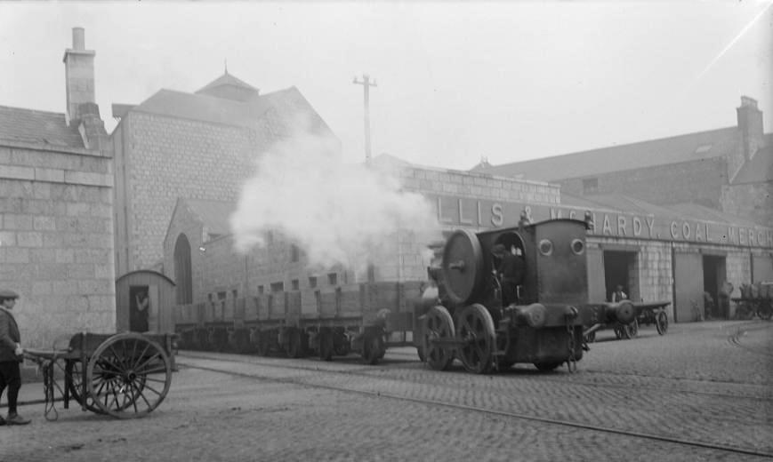
A small Steam Traction Locomotive of Caledonian Northern Scottish Railway pulling empty Coal Trucks at the junction of Regent Road & Regent Lane, Ellis & McHardy Coal Merchant’s Yard & buildings on Regent Road, a young boy with a handcart in Foreground & Coal being loaded in Bags on to Flatbed horse-drawn Carts.

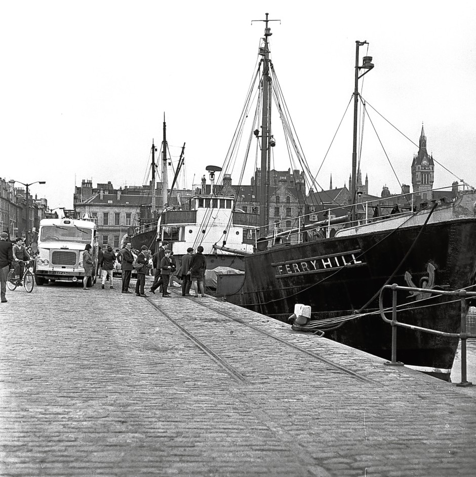
Collier Ferryhill at Blyth on the Tyne loading coal.
Loss of Ferryhill, 21st January 1940: Aberdeen Coal Company
The swift & tragic Sinking of the Ferryhill was distinguished by the brave conduct of her Chief Mate, James McGill Ovenston, who tried to save the Chief Engineer by getting him onto a Door that had floated clear of the Ship. Unfortunately, his rescue bid was in vain & he and 2nd Engineer John King Grassie were the only 2 Survivors. They were in the Water for 35-mins before being picked up. James Ovenstone was later awarded the OBE for his Gallantry. Struck a Mine laid by a German Submarine. Exact location Mined by U-61 1½-miles North St Mary’s, Firth of Forth. The Wreck was dispersed using Explosives in 1955. Her Hull was Owned then by the Ministry of War Transport who had no interest in her Cargo – 1200-Tons of Coal.
Aberdeen Harbour Admiralty Chart 1961
