
A Concise Harbour History
The Evolution of Aberdeen Harbour from the Denburn Stream to a large Wet Dock and the major reclamation of Land by the Diversion of the River Dee & Dredging of the Inches.
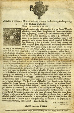
This Act was issued in Edinburgh on 7th July 1682. It regards rebuilding and repairing Aberdeen’s Harbour. The Act tells us that Aberdeen’s Magistrates and Town-council had Petitioned the King’s Privy Council over re-Building the Harbour. They argue that Aberdeen’s considerable Maritime Trade needs a functioning Harbour. The Weather was preventing them from managing their Harbour. They speak of the Banks of the River Dee being washed away by Currents. They announce that they need a Bulwark along the North Shore to match that of the South Shore. This would cost at least £1,000, roughly the equivalent price of 230 cows. They justify their request by saying that they rarely burden their Neighbours. The Act continues by saying that the King’s Privy Council accept the petition for a ‘Voluntar Contribution’ to be collected for the Harbour. They also say that they will recommend to Ministers, Archbishops & Bishops to contribute to the Fund. The Broadside is signed by Wil Paterson and was Printed in Edinburgh by the Heir of Andrew Anderson, printer to the King. Aberdeen’s Harbour was established in 1136 by King David I of Scotland. In the mid-18thC, it was Ransacked by both English & Scottish Forces. It was not until 1773, the best part of a century later, that Improvements on the Harbour begun in earnest. Before this act, through the 17thC, the Harbour was continuously worked on. The Wharf, for instance, was expanded Eastward from 1623 through to 1659. The Harbour remained Dangerous & Difficult to Access due to a Sand Bar across its Entrance. At High & Low tide, the Depth ranged from 2 to 15-ft of water. Floods were Common, and Ships were sometimes Swept out to Sea. (Victoria Elizabeth Clark, The Port of Aberdeen (1921), pp. 47-49.)
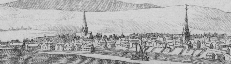
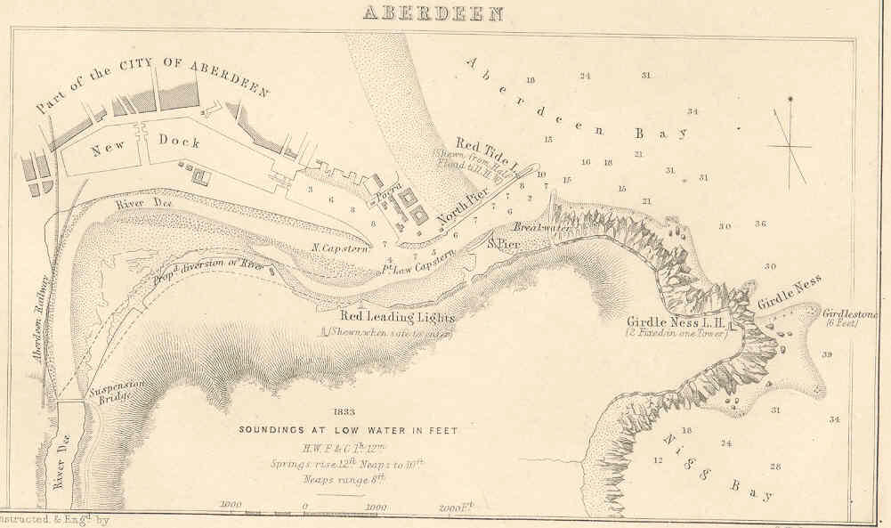
The Harbour of Aberdeen has grown up over the Centuries in the Estuary of the River Dee, originally an area of Sandbanks and waterlogged Marshes, roughly triangular in shape and set on an East-West axis; including Marshland at the Inflow of a small Tributary, the Denburn, it may have measured about ¾-mile (1.2km) from North to South at its Inner (or West) end by 1¼-miles (2km) from West to East. The Dee appears to have entered it at the South-West corner, on a Northerly Course, and then to have turned Eastwards to traverse it by a series of diffusing Channels, which left between them Islets, mainly Tidal, known locally as ‘Inches‘. The Northernmost of these Channels evidently followed a Course more or less corresponding with today’s Upper & Victoria Docks and was here Reinforced by the Denburn, which had joined it on its Curve from the Northerly to the Easterly Course. It was on this Channel that the Town’s Harbour Lay, the other cutting through the Inches on their various Courses which seem to have been liable to change from Period to Period; their disposition, for example, as shown respectively on the Maps of the Rev James Gordon (1661) & George Taylor (1773) being markedly different. East of the Inches lay a Pool of Open Water, which narrowed towards the Apex of the Triangle where the River debouched into the Sea. As a Site for a Harbour, this Tidal Area suffered from a number of drawbacks, the most serious of which was a Sand Bar obstructing the Entrance. Coastal Currents & Northerly Winds kept Sand in movement from the vast Reservoir formed by the Links & Dunes stretching Northwards to beyond the Ythan, and this Sand, when its movement was checked by the Projection of Girdle Ness, tended to settle down and form a Bar outside the Mouth of the Dee. Under certain conditions of Tide, the Depth of Water on the Bar might decrease to a few feet only; the Bar itself was unstable, and its presence could also make the turn from the Open-sea into the River-mouth a dangerous Manoeuvre for Ships. In addition, the Tidal area lacked protection from Easterly Storms, and the Denburn Channel leading to the Town was shallow & obstructed.

Measures of improvement appear, on the available evidence to have fallen into 3-Principal Phases. Records of the 1st of these begin with a Charter of 1281 which mentions a Bulwark running Southwards from the foot of Shiprow, and thus places the early Medieval Harbour much in the position of the Nucleus of the later Port. Nothing further is said as to the size or character of this Work, but the North-South alignment that seems to be implied for it recalls the ‘Old Pier’ that is marked on Taylor’s Plan of 1773, being shown not as connected with the Town’s Quay but as projecting towards it from Trinity Inche opposite, with a narrow gap between its Head and the Quay at a short distance West of the Weigh-house. Nothing more seems to be on Record until 1399, when the ‘Key of Aberdeen’ is mentioned in a Contract; the ‘Key‘ is described as a ‘Platea Communis’ in 1413, in 1453 it was repaired, and in 1484 either repaired or re-Built. In 1844, remains of an Ancient Quay-wall, then believed to be older than 1400, were dug up somewhere near the Weigh-house. Other late-Medieval improvements were the erection of Beacons at the Harbour Entrance, the clearance of obstructions from the Channel, further repairs to the Quay in 1512 & 1526, and the installation of a Crane in 1582. The Work of 1526 called for the use of hewn stone, a fact which suggests that the earlier Quay or Bulwark may have been of rough Drystone Masonry & Timbering.
A 2nd Phase, in which Improvement moved at a brisker Tempo, seems to have begun at the turn of the 16th & 17thCs. Thus in 1596 the Burgh was Authorised to apply for an Imposition for the Building & Repairing of its Bulwark, Pier, Shore & Harbour, and this language must imply Work on a considerable Scale. In 1609 a serious attempt was made to deal with the Bar by means of a Bulwark, the ‘South Pier‘, on the South Shore of the Entrance, so Sited as to deflect the River’s Current Northwards, directly onto the Bar, with the idea that it should wash away the Sandbank. This Bulwark was of Drystone Construction with Timber Stakes and took 3-yrs to Build. The Bar, however, continued to give trouble, as the Entrance-Channel, was unable to carry off Floods, with the result that Water tended to Back Up and Overflow the Quays. In 1610, David Anderson removed the great Boulder known as Craig Maitland from the Channel by floating it with Empty Barrels at High Tide. Thus David Anderson of Finzeauch, commonly known by the appellative of “Davie dae a’-thing,” was noted for his Mechanical Genius, and in the year 1618 promoted the Improvement of the Harbour, by removing the large Rock Craig Maitland which lay in the Middle of the Natural Harbour Entrance Channel.
Conditions existing in the 17thC are illustrated by a Document of the time. This distinguishes between the ‘Portus‘ which it places a 1,000-Paces from the Town, and the ‘Cothon‘, by which it evidently means the Quay discussed above, and it records a Plan to extend the Latter Downstream so as to join it up with the Former. At this time, High Tides covered everything as far Upstream as the Quay, thereby giving small Craft access to the Quay while the Larger Vessels discharged their Cargoes ‘in portu‘. Work on this Scheme was begun in 1623, but was delayed by the Wars of the Covenant and was only completed in 1659. A generally similar picture is presented by Gordon’s Account (1661) and its accompanying Plan; Gordon places the Quay, with a Weigh-house built c.1634, at the Quay’s Head, somewhere just East of Shore Brae, and carries it thence to Futty, which occupied an area behind what is now Waterloo Quay He gives the distance as 500-Paces, which agrees pretty well with his Plan. The extension of the Quay cut off, and permitted the reclamation for Agriculture of, a large area of what had previously been Tidal Ground (Shorelands). The Latin text reads ‘e macerie arena congesta magno labore demum anno 1659 peractus agger’, but this does not seem to justify the rather improbable statement that the Work was faced on both sides with Drystone Masonry and had a core of Sand. Futty is described as stretching along the Shore for some 400-Paces, and as being inhabited mainly by Fishermen & Sailors; Ships lay at Anchor off it, no doubt primarily those of too great a Draught to reach the Town’s Quay. It also possessed a Dock for Building & Repairing Ships. Beyond Futty lay the Fishing Boat Harbour of Pockra, where, as at Futty, the Plan shows Ships lying at Anchor.

A 3rd Phase in the Harbour’s Development may be thought of as having opened in 1770 with James Smeaton’s Report on really far-reaching Developments. The Outline here given of the ensuing course of events has been put together from the sources already quoted without individual references, to avoid such a plethora of these as would have obscured the core of the narrative. The state of Affairs that existed when Smeaton arrived is illustrated by the Plan prepared by Taylor in 1773, which differs from Gordon’s Plan in important respects. For example, Taylor shows the Main Channel of the Dee as separated from the Harbour by a block of Tidal ‘Inche‘, with the Harbour Sited on a subsidiary Channel lying North of the ‘Inche‘ and representing the Tidal portion of the Mouth of the Den Burn. From the Mainstream, slightly higher up, there Branches another subsidiary Channel which joins that of the Harbour at the downstream end of the Extended Pier that is described & planned by Gordon, while the Mainstream itself runs out into the Open-water off Pockra & Torry. In so doing, it passes North of the Point Law ‘Inche‘ but also throws off a Branch which passes South of Point Law, forming Torry Pool at the Village.
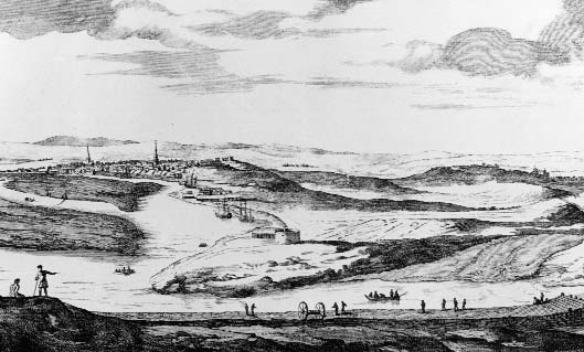
Torry Pier, from John Slezer’s View of ‘New Aberdeen from the Torry Blockhouse’, of 1693 The Footdee Blockhouse is evident. In the upper Quayside, Trinity Church & the Weigh-house are present with St Nicholas Kirk and the Tollbooth represented. The Eastward extension of the Trinity Wharf, whereby a fine Meadow of Ground known as the Shorelands was reclaimed, this was carried on slowly (1623-59), and before 1661 a Shipbuilding Yard had been constructed at Footdee: The Torry Bulwark is shown where large Ships would Berth and be unloaded by Carts or Lighters. The Salmon Fishings are active and a Salmon Pen stands in shallow water. The Fishing Community of Fittie is evident as is the old Blockhouse. Two Windmills are present one fully Sailed West of the Town and the other unsailed at Porthill above the Back Butts. All improvements notwithstanding, Harbour Navigation continued to be difficult and perilous, owing to a Bar of drifting Sand, above which at Low Tide there was scarcely 2ft Depth of Water.
Torry Pool possesses a Pier, and from Torry, a long Bulwark, presumably the South Pier of 1609, runs Eastwards along the Southside of the Entrance-channel; one of Slezer’s Drawings (1693) shows this Work as being of Timber & Masonry. A ‘New Pier‘ has also appeared at Pockra. The factual reliability of such Plans, however, should not perhaps be taken entirely for granted, as another, of 1746 by G & W Paterson, shows a somewhat different arrangement of Channels & ‘Inches‘ from those of either Gordon or Taylor; though again the discrepancy may be due to the Sandbanks‘ instability from one period to another owing to River Spates.
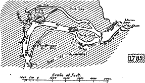
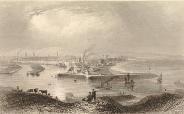
Alexander Milne’s Aberdeen Map of 1789 Clearly defines the later Works and the Old Harbour.
A Council Register describes how the Aberdeen Ship “William” travelled from Aberdeen to New Found Land (Newfoundland) in 1596. It is believed to be one of the earliest documented references to the Voyage of a Scottish Vessel to North America. From an earlier reference in the same volume it is known that the “William” had arrived back in Aberdeen in May 1596 from Bordeaux with a Cargo of Wine, having stopped at Burntisland on Route. The entry in which the Ship is mentioned as having crossed the Atlantic relates primarily to Debts incurred by Patrick Donaldson the younger, a Burgess of the Town & Burgess William Findlay, the Master of the “William”. The records reveal that both Patrick & William were involved in the fitting-out & freighting of the Vessel between it leaving Aberdeen in July 1596 and its return 4-yrs later. The other Partners & Owners in the Newfoundland Venture are given as Archibald Smith & Burgess Alexander Kempt. A Colin Campbell is also noted as being on Board the Vessel as was a Carpenter by the name of John. The precise nature of the Cargo on the outward Voyage is not known, however, from later entries in the same volume it becomes clear that the “William” returned to Aberdeen from North America via the Port of Aveiro in Portugal where it picked up a Cargo of Salt, most probably destined to be used for Preserving Fish & Meat. Remarkably, several of the Portugal to Aberdeen Crew are also named: John Barclay, Alexander Currie, David Morton, David Easton, William Brown, Robert Fleming, Paul Fraser, William Young, & John Dow. It is possible that some, if not all these men, might have been Crew members on the Newfoundland Voyage. They had paid money to Patrick Donaldson, one of the Owners and the Ship’s Clerk, to buy their Share of the Ship’s Cargo of Salt. On arrival in Aberdeen, the Owners refused to pay the Crew their whole Share as the Cargo was spoiled due to a Leak in the Ship’s Hold. The dispute then came before the Burgh Court and was recorded in the Council Register. In 1596, when the “William” made her long Westward Voyage, Scottish Interests in North America were still very much in their infancy. The tentative Trading Contacts of which the “William” was one example were yet to develop into the Settlements that became Home to the Scottish diaspora during the 17th & 19thCs.
As early as 1659, a Quay was formed along the Dee towards the Village of Footdee. “Beyond Futty,” says an old Writer, “lyes the Fisher-boat heavne; and after that, towards the promontorie called Sandenesse, ther is to be seen a grosse bulk of a Building, vaulted and flatted above (the Blockhouse they call it), begun to be builded anno 1513, for Guarding the Entree of the Harboree from Pirats and Algarads; and Cannon wer planted ther for that purpose, or, at least, that from thence the motions of Pirats might be tymouslie foreseen. This rough piece of Work was finished anno 1542, in which yer lykewayes the mouth of the River Dee was locked with Cheans of Iron and Masts of Ships crossing the River, not to be opened bot at the Citizens’ pleasure.“
A Plan, drawn by John Home, shows Aberdeen Harbour in 1769. At this date, the Harbour was Shallow & Tidal, with many Sandbanks or Inches. The Dee Estuary entrance was narrow and partly blocked by a large Sandbank, the ‘Barr‘. The Girdleness Lighthouse was not completed until 1833, so the Rocks to the South of the Harbour were also Unlit and a Major Hazard to Shipping. This made the Port very difficult to access, especially for Larger Vessels. The Plan shows many Vessels off Aberdeen Bay but this number probably reflects Artistic Licence.
In 1773, the Bar was nearly Dry at low water, and accordingly, to deepen the approach, Smeaton proposed the Building of the great North Pier. This work was of Rubble Masonry faced with Ashlar, some of the Blocks weighing over 3-Tons and Masses of up to 40-Tons being used to protect the Foundations. The Pier was carried out Seawards from Sandness, on the Northside of the Entrance-channel, at right-angles to the Line of the Shore, for a distance of 500-yds (457M); its breadth was nearly 30ft (9.1M) and its Parapet stood 15ft (4.6M) above High-water Level. Its objects were to prevent the influx of Sand from outside the Entrance, and to direct the River’s Deposit into the path of a Tidal Current which would carry it round Girdle Ness. It was under Construction from 1775 to 1781, and is shown on the Map of 1773 as a ‘Design’. In 1789 it was found necessary to narrow the Entrance-channel, Smeaton’s Pier having been sited rather too far to the North and to this end ‘Abercromby’s Jetty‘ was built near its West End
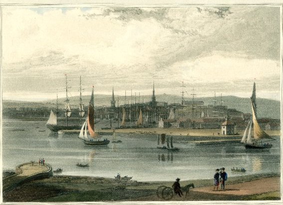
An Illustration from Ayton’s ‘Voyage Round Great Britain‘, Vol-VI. 1822: Entrance to Aberdeen Harbour c.1822, with Sailboats approaching from right, seen from the Torry Bank & Greyhope Road, with Horse-drawn Cart and 2-Kilted Figures on the Road in Foreground, and others on the Capstan Pier above the Water with Salmon Fishing or Ferry Cobles; the Ancient Roundhouse & Fittie Buildings on the opposite Bank including the Ferry Inn Tavern, and Smeaton’s Catchment Pier. Ships & Boats moored in the Lower Jetty at Pocra; the Mither Kirk, Tollbooth & Barracks on Castlehill with Heading Hill in the background, and higher hills in the distance; a very pre-Industrial Scene.
Later by recommendation of Telford the North Pier was Extended (1810-16) to a further length of almost 900-ft, at a cost of £66,000: and to protect it, a Southern Breakwater, nearly 800-ft long, was finished in 1815, at a cost of £14,000 more.
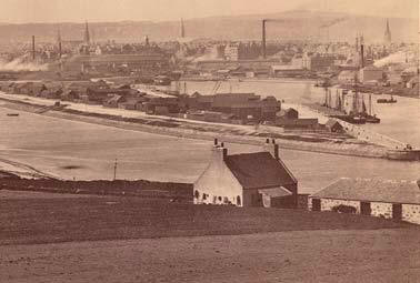
The next great undertaking was the Construction (1840-48) of the Victoria Dock, 28-acres in Extent – with 7½-acres above Regent Bridge, – with 2053-yds of Wharfage & Tide-Locks 80-ft wide, the depth of Water on whose Sill is 21-ft at ordinary Spring Tides. This left about 18-acres of Tidal Harbour, and so things stood till December 1869, when Work commenced on the Southward Diversion of the Dee from the Craiglug Suspension Bridge Seawards. The new River Channel, curving a little over a mile, and was at its bottom 170-ft wide, was completed at a cost of £51,585 in 1872, the total Sum expended on Harbour Improvements up to that date since 1810 amounting to £1,509,638.
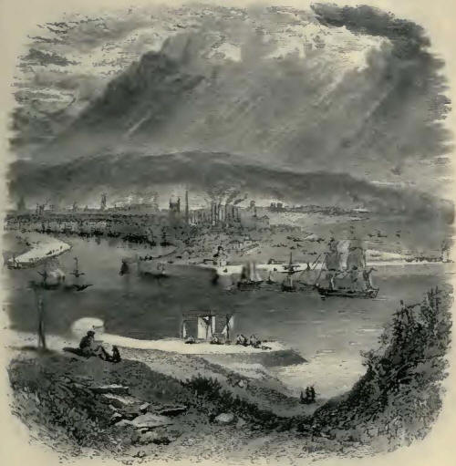
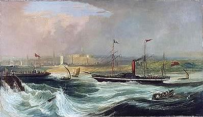
View of the City from Balnagask above the South Pier or Bulwark of the Dee at the mouth of the River, Steam & Sail Ships passing into Port at centre, the Chimneys of the Houses & Industrial Factories smoking, the Barracks at Castlehill in the centre distance; Seaton’s Initial North Pier & the old South Breakwater, the Lower Pocra Jetty with the Roundhouse – after William Henry Bartlett (1809-54), Illustration to William Beattie’s ‘Scotland’.1838. Etching & Engraving of a more Industrialised City and the onward Development of the Harbour.
Other Works under the Act of 1868 have been the Building of a New Easterly South Breakwater of Concrete, 1050-ft long & 47-ft high, at a cost of £76,443 (1870-73): a further Extension of the North Pier by 500-ft, at a cost of £44,000 (1874-77): and the filling up of the Dee’s old Bed, on which, in a Line with the Dock-gates, it is now (1881) it was proposed to form a Graving Dock, 559-ft by 74-ft, as also gradually to rearrange the Docks at a Total Cost of £72,000, by Building a new end to the Victoria Dock, with Swing Bridge & Railway across, removing old Regent Bridge and approaches, lowering the Dock-sill, providing a Caisson Bridge, etc.

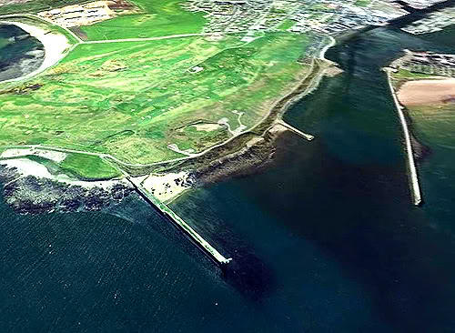
Girdleness Lighthouse, with 2-Fixed Lights, 115 & 185ft above mean Tide, was Built in 1833 to the South of the Harbour Entrance, which, widened now to 400-yds, leads out of Aberdeen Bay, a safe enough Anchorage is this with Offshore Winds, though not with a North-East, East, or South-East Wind. Valued at £13,874 in 1881, the Harbour is Managed by 19–Commissioners chosen from the Town Council, and by 12 other Elected Commissioners. The aggregate Tonnage Registered as belonging to the Port was 310 in 1656, rising to Sailing Vessels of 92,217 & 53-Steamships of 25,965 Tons in 1879.
For a Ship to be Moored to a Buoy in the Harbour Centre normally meant it was in Quarantine normally the result of Pestilence or Contagion on Board. The temporary Floating Jetties or Decks with Dingy’s ‘ashore’ are a faded reason now – perhaps for the chance defouling or painting of areas of the Ships Hull at Shallow Draft after unloading before Pontoon Docks became available. Flat bottomed Painters ‘Sculls’ with Oar Propulsion from the rear were also used.
The Harbour was, for many years, an Open Basin, with a Sand Islands in the centre called the Inches, which separated the Channel of the River Dee from the Denburn Stream forming the Trinity Shore Harbour, on the Northside of it; the only Building was the Quay-head, which, having become ruinous, was repaired in 1484, and rebuilt in 1527, with Stone brought from Dundee. A Pier was Built in 1607, which, in 1623, was extended from the Quay-head towards the Fishing Village of Fittie, by which means a considerable portion of Land was gained from the Basin, and which now forms part of the Town. In 1755, the Magistrates & Council engaged Mr John Smeaton, an eminent Engineer, to Improve the Harbour; and in 1770, he proposed a Stone Pier on the Northside of the Entrance, which, confining the Stream of the River within Narrow Limits, and would thus Scour a Bar of Sand that always accumulated there. In 1773, an Act of Parliament was obtained, and the improvements on Mr Smeaton’s Plan were carried into full Operation, at a cost of £18,000. This Pier was 1200-ft in length, 20-ft broad at the base, 12-ft on the summit, and 16-ft in height at the Western extremity, and gradually increased towards the East where it was 36-ft broad at the base, 24-ft on the summit, and 30-ft high; it was faced with Blocks of Granite, many of which weighed more than 3-Tons each. The Pier, however, by a deviation from Smeaton’s original Plan, being erected too far towards the North, and – a great Swell was occasioned in the Harbour at High Water, to remedy which, a Breakwater Spur was projected from the West End of it, towards the Channel of the River, with complete effect. The Harbour was further improved by Thomas Telford, who, in 1810, extended the Original Pier 900-ft further towards the East, where it terminated in a Circular Head, 60-ft in Dia, which was destroyed by the Sea in the following Winter and rebuilt with a lower Slope towards the Sea. A Breakwater 800-ft in length was also Erected, on the Southside, by which the Harbour was protected from the South-east Storms, and the depth of Water increased to 19ft. Commodious Wharves were formed along the Harbour, on the South-west side of the Village of Futtie, and Quays nearly 4000-ft in length have been constructed: the Inches, also, are now built up and connected with the Town by a 2-Section Swivel Bridge opposite the end of Marischal Street. In 1843, an Act of Parliament was obtained for converting a large part of the Harbour into a Wet Dock, and Operations for that purpose were then in progress. The Custom-house or Weigh-House situated on the Quay, was a neat building purchased by Government, and fitted up for the purpose; the Establishment consists of a Collector, Comptroller, Land & Tide Surveyors, 4-Landwaiters, 28-Tide-waiters, 6-Boatmen & other Officers.
Virginia Street was Laid down in the mid-18thC on the reclaimed Shorelands that ran from the Weigh-house to Footdee, as were Commerce Street, Sugarhouse Lane, Water Lane, Pork Lane (now Mearns Street), James Street. and the lower end of Marischal Street. Until then, the Waters of the Harbour had extended to the foot of the Castlehill at High Tide. The name of Virginia Street. refers to the expanding Trade with the Americas, as does that of nearby Sugarhouse Lane for the West Indies.
Now, what was the name of the popular guy who embellished the Aberdeen (Fish) Box Pool – – Joe Little? Blatant Advertising, when left afloat in the Harbour or lying almost everywhere around the Fish Market, abandoned or shed from flat back Lorries.
Now as a wee ruffian – when I would always ‘gin doon tae’ the Harbour to play and meet with the Clydesdale Horses, Hingin’ aff Tailboards of Lorries, skiddin’ doon slippery Jetty’s & Wharves, dodging Shunting Trains and free coasting driverless Wagons, bouncing on sawn Timber Plank Stacks, climbing huge waste paper Stacks, jumping between Barrels & rinnen’ oe’r the piles of stinking Argentinian Cattle Hides alive with Flies, Slime & Anthrax on the Quaysides, let alone the greasy Harbour Boat Staircases, Faroese Fishermen and possible Perverts – my Mither jist said ‘mind fit yer dee’in Eddie’ Now why was she so intent on undermining my personal confidences and fearless belief in my own Survival Abilities?
Snuffy Ivy was a legendary Aberdeen Prostitute – along with contemporaries Cove Mary, Biscuit Facey, & Cinnamon Hole – the clandestine Trade is rife even today on the Harbour Pubs & Approaches. Undoubtedly a fair looker in her day, by the time Snuffy became Infamous in Aberdeen she was ‘Weel past her best‘. So-called because of her sniffing & speech impediment by which her voice was directed through her cleft palate & nasal cavities rather than directly from her mouth – an affliction not easily repaired in her days. A Mannie in the Co-op in Commerce Street counted the cost of the dairy products purchased in exactly the same fashion of speech – snorting the words – Two ‘n two, three ‘n three, four ‘n four etc in a distorted nasal drawl.
“Knock Knock”
“fath’s thare?”
“It’s the Police”
“Weel yith’ll hae tae waith yer thurn. A’m bithy jist noo” – said Snuffy
Oh! yer back are ye Eddie – Aye Ma – fits at a’ o’er yer troosers – tak em aff and a’ll wash em fer the mornin’.
I drew a great comfort in your Mother’s warnings to you, but of course, Mothers are like that. My own mother constantly urged me to eat my eggs, eat lots of cheese and drink lots and lots of milk as growin‘ loun. In my youth, I suspected that she wanted me to grow up to become an Arnold Schwarzenneger, but then the dreadful truth dawned on me. Ma obviously had me insured for a lot of money and was actively encouraging me towards a Heart Attack or Stroke. Her master plan to remove me from the Census fell sadly ‘agley’, and I am still here but with her absence. Still here but with the terrible doubt in my mind -“if you can’t even trust your own Mother, then exactly who can you trust?” Bankers, Accountants, MP’s of varying colours, and the smoothie Tony Blair all sprang to mind but were immediately rejected. In the words of the late, great Wee Johnny Laurie “We are all Doomed, Captain Mainwaring – Doomed”. – Don Leiper RIP
Improvements inside the Harbour were recommended in later years by several leading Engineers, the names of Rennie, Telford, Walker, Gibb & Stevenson all appearing in the Record, as well as that of James Abernethy who was appointed Resident Engineer in 1840. Rennie was Consulted in 1797, and, although his recommendation were not carried out, it is important to remember that they included the Formation of a Wet Dock. Telford made a Report in 1802, and a Bill based on it was passed in 1810 which Authorised an extension to Smeaton’s North Pier, the Construction of a Wet Dock & Spillway, and the Diversion of the River’s Current. By 1829 all these Works had been carried out apart from the Wet Dock, of which only the Quay-walls had been completed; the Length of the North Pier, no doubt in its extended form, is given as 2000-ft (610M) at this date. Other major Works of this Period were the South Breakwater of 1812-15, stretching 800-ft (244M) from the Southshore at a point outside the Entrance and reaching to within 250-ft (76M) of the end of the North Pier & Wharfage along the whole length of Waterloo & Regent Quays.
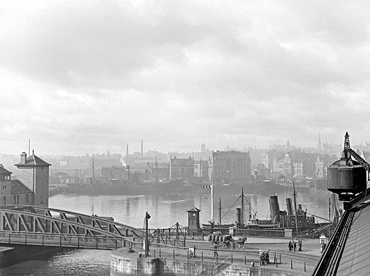
The Upper Dock as viewed from the Regent Quay 2-Storey Goods Shed Crane, horse-drawn Cart crossing Regent Bridge, North abutment and greasy Harbour Boat Steps, Gate Operators Bothy, several Steam Cargo Vessels within Upper Dock, which was once home to 3-Shipyards. Regent Bridge Engine House, Buildings of South Market Street, Guild Street & Trinity Quay, Signal Mast by the Bridge, Telephone Box in the middle of the Street opposite the Bridge, Steel Railings, Bollards, Wester most Crane on the Roof of the Regent Quay 2-Storey Sheds is just visible.
To attempt to describe in detail the whole process of the Harbour’s Development in the 1st-half of the 19thC would not be a rewarding exercise, partly for the danger of obscuring the Wood through over-attention to the Trees and partly because the process itself continued long after the terminal date of this Study. Reference, however, may usefully be made to a general account of what was done between 1840 & 1846 as given in evidence to the Tidal Harbours Commission by James Abernethy, the Resident Engineer; this shows that, in the course of these years, the Harbour as a whole had been widened & deepened, some Sandbanks at the Entrance had been Dredged away, part of Abercromby’s Jetty had been found to be unserviceable & removed and likewise old Warping-posts & Cairns of Stones which caused obstruction in the Fairway. At the same time, 330-yds (301M) of new Wharfage had been built and effective Leading Lights set up at the Harbour Entrance. The depth of Water at the Entrance was now 19-ft (5.8M) and the Width between Pier-heads 380-ft (116M); that between Pockra Jetty and the Point of the ‘Inche‘ opposite it was 350-ft (107M). Navigation at this point was difficult, especially for long Steamers, as it was necessary to make a turn of almost 90°.

On a broad view of this Phase of the Harbour’s History, it is the enclosure of the Docks that stands out as of Prime Importance. In effect, the old Channel onto which the Town’s Quays had fronted was turned into a Wet Dock of 34-acres (13.8 ha), with a depth of 16-ft (4.9M) and capable of accommodating up to 300-Vessels. In 1847 its Entrance-lock was still under Construction; its Gates were made of Iron. An Admiralty Plan of 1833, evidently marking features which were then still unfinished, shows a Large Dock with a smaller Upper dock abutting on its West End, while the Dee followed a Course slightly further to the West and corresponding more or less with today’s Albert Basin. Further Diversion of the River towards the South was Authorised only by the Bill of 1868 but its New Course is marked, as a Project on the Ordnance Survey’s 1st 6-inch Map of the area, which was Surveyed in 1862. It is interesting to find that the Engineers and others responsible for the Harbour’s Improvement devoted much attention to the possible effect of the Docks on the action of the River at the Bar. The question was whether the Diversion of the River’s Course and the Embankment of some 80-acres (32 ha) of Tidal Ground would so diminish the amount of Backwater available at the Fall of the Tide as to affect the River’s ability to Scour out the Bar, the same problem, in fact, as was noted at Montrose. The Tidal Harbour Commissioners recognised that to compensate for the Enclosure of the Docks, the River’s Channel should be deepened above the Victoria Bridge to increase its capacity as a Reservoir.
A Port existed at Aberdeen at least from the 14thC, but it was not until 1770 that a start was made on the Modern Harbour by Commissioning a Report from John Smeaton, following which the 1st North Pier, one of the most remarkable in Britain requiring exceptional Engineering talent to overcome Storm Effects, was Built from 1774 and twice extended later. A Southern Breakwater was completed in 1815 and another further East from 1870–73. From the Pounding they receive from the Sea both have required regular maintenance. In 1810 Telford proposed a Scheme for a Large Dock adjoining the North Shore and what was to become Waterloo Quay to be created by impounding Water in the Harbour at High Tide by means of an Entrance Lock. Between 1816 & 1829 very little was done except Dredging. The 1831 Version of this proposal formed the basis for the Victoria Dock Project later developed by James Abernethy. About this time Telford also advised on the New Channel for the Dee, reclamation of the Inches, new Wet Docks & Quays & Dredging. The cost of the work done under his direction amounted to £160,590. In 1843, after receiving Reports from James Walker & Alexander Gibb, the Harbour Commissioners executed the Plans of Abernethy, their Resident Engineer, and the 28-acre Victoria Dock, and an Upper Dock West of Regent Swing Bridges was Built by 1848 with 2-Entrances 60ft & 70ft wide & about 20ft deep, one with a Lock for the Passage of Ships and the other with Ebb-gates. From 1869–72 the Channel of the Dee was realigned Southwards to Wellington Suspension Bridge at a cost of £51,585 and the old Channel was converted into a Tidal Basin with Commercial Road to the North and Albert Quay to the South. With the advent of the Oil Industry, in the 1970s Victoria Dock was redeveloped and the Tide Locks were removed in 1975 making the whole Harbour Tidal, with Deepening by Dredging as necessary.
The Port of Aberdeen : a History of its Trade & Shipping from the 12thC to c.1915
