Poynernook Road
From Lower Market Street to Palmerston Road
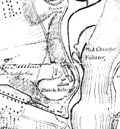
Pynner Nook – This area may be the remains of a small Peninsular named `Pynner Nook’, seen on Taylor’s Map of 1773 of the Area.
Poynernook Area – Between College Street & Joint Station. AB11
The Pynours themselves have left their mark on one of the Localities of the Town, namely, the Poyneneuk, consisting of the Level Land now occupied by the Joint Railway Station & Pirie’s Union Works. It is probable that the whole of the District had at one time belonged to Philip Arbuthnot, who divides the Honour with Sir Reginald de Chein, in having founded the Monastery of the Carmelite or White Friars on the South Side of the Green, near by where Carmelite Street now stands, Chein bestowed the Income (£2) from the Lands of Blackwater & as the Friars became possessed of the Property in question we assume (which is perhaps too Bold) that their other Founder Bestowed it at all Events, at the Reformation the Crown Confiscated the whole Property, & as in many such cases tranferred it at a nominal purchase price to the Royal Burgh of Aberdeen. In the Burgh Sasines there is one Conveying the Pynour Craft, Signed by King James, & dated at Stirling, 26th October, 1583. The Croft is thus described:-
“Preceptum sasine terrarum quondam fratrum predicatorum et Fratrum alborum. Croftam vocatam pynoumuke jacentem inter lie denbume ex orientali et croftas Gilbert Menzies ex occidentali fyndmark ex austral! et viam publicam ex boreali. Croftam vocatam Ladycroft jacentem inter lie Pynour Croft ex orientali croftam Martini howesoun ex occidentali croftam Magistri Jacobi bumett ex australi et Croftam dicti Joannis ex boreali.”
On 29th November, 1585, two years later, a charter is given to Robert Chalmer by the Provost, Bailllies, and Council of the Poynerneuk & 2-adjacent Crofts:-
“Solas et integras croftas terre cum pertenentiis subscriptis vulgo appellat the Sow Croft, Hill Croft and Poynerneuk olim dictis fratribus Carmelitarum incumben contigue adjacentes.”
A notarial Instrument is still wanted, however, to Legally connect the Pynours with the Neuk. In default of it we are thrown back on our Conjectural Powers. It is pretty certain that the Pynours were not possessed of Landed Property, or indeed any Property at so early a date As the spot of Ground in question was known by their name, it may, however, have been Rented by them as an Agricultural Croft to be worked in their spare time & if held for a long series of years, as it may well have been, have become at last associated with their name. I would venture another conjecture, that as the River in olden times made a distinct Bend there, forming a kind of Cove, and as the lands there were all more or less likely to be Submerged in times of Flood & High Tides, the locality may have been a sort of rendezvous for the Craft a Haven for any Boats or Utensils held & employed by them in the conduct of their Business. However it has been, there must have existed some visible connection at one time. It is gratifying to see that the name is likely to be Perpetuated in the name of one of the New Roads on the reclaimed Ground, in the near Neighbourhood of the Old Pynour’s Croft.
This word is of doubtful import & probably unique. It may mean a Mark to find or determine Property Boundary – A March Stone.
The Whaler Flamingo, which belonged to Merchant & Shipowner Provost Alexander Nicol (d.1880) & William Nicol, on her arrival from Davis Straits, was not Berthed at Poynernook at the Head of the Harbour like the 2 other Aberdeen Whalers, Pacific & St Andrew but got refurbished, and was sent away to some Foreign Port, not perhaps very far away, for a Cargo, and so went on until the Spring arrived, when it was about time to start again for the Frozen North. He also owned the early Historic Clipper ‘Scottish Maid‘ built by A Hall & Co 1839
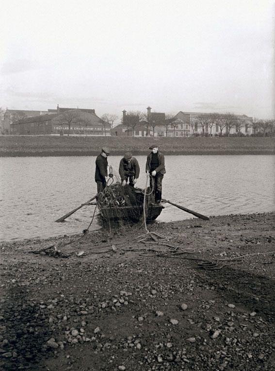
It was part of the Harbour Improvement scheme that the Inches should be ‘made up’ far enough to be above the level of the highest Spring Tides and to shut up all Waterways between the Dee & the Harbour. Of these, there were 2, one coming in about Commerce Street & another farther West. The former took often a large quantity of the River Water when the Tide began to Ebb, and the Salmon Fishers had to be compounded with before it could be shut up. The other was valued by the Brickmakers at Clayhills because by it they could get Coals brought to the Works either via the River Dee, or by the Harbour at Spring Tides. To satisfy them the Pier was carried as far as Poynernook, with a Channel alongside.
Cotton Mill owned by Forbes Lowe & Co, Cotton Mill at Poynernook a Spinning & Cotton Twist Mill was established in 1800 on the Southside of the Denburn rivulet, the Machinery of which was propelled by Steam. In 1838 there were 368 Workers of which 200 were under 18yrs and Spinners were paid by piecework for so many hanks of yarn. It was later taken over by Pirie’s to become the Union Works, Poynernook.

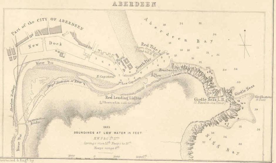
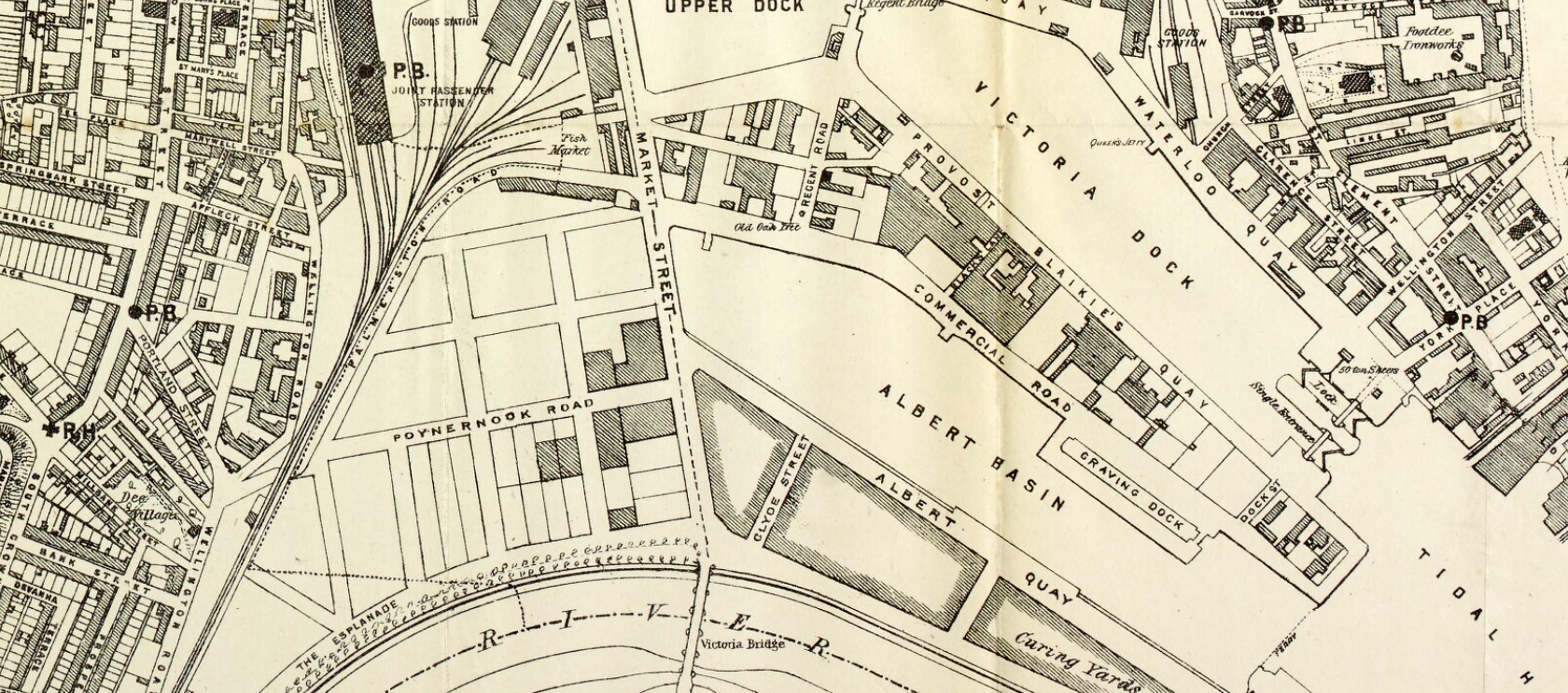
The course of the River near the Mouth was Diverted South between 1869-73, at great expense, by the Town Council, and in this way, a considerable area of Land was reclaimed for Feuing purposes. The Northernmost of these River & Spillwater Channels evidently followed a Course more or less corresponding exactly with today’s Upper & Victoria Docks, Albert Basin respectively and this was also reinforced by the Denburn Stream, which had joined it on its curve from the Northerly to the Easterly River Course. It was on this Channel that the original Town’s Harbour & Quay & Weigh-house lay, the other Channels cutting through the Inches on their various Courses which seem to have been liable to change from early recorded Period to later recorded Periods. Their disposition, for example, as shown respectively on the Maps of the Rev J Gordon (1661) & that of George Taylor (1773) being markedly different. East of the Inches lays a Pool of open water, which narrowed towards the apex of the Triangle where the River debouched into the North Sea at the Harbour Bar & Aberdeen Bay.
How different the Scene today, with the Water confined into definite Channels – the Docks, Albert Basin & the River Dee. The old Mud-Flats were reclaimed from the Tide, the Mainstream of the Dee was diverted into a New Channel, and where once the Fluke & Saithe swarmed in the shallows & the Crabs squattered in the Mud, we have today busy thoroughfares, bustling Factories, and deep-sheltered Docks crowded with all the various Craft the Sea carries.
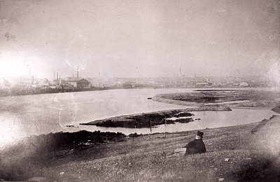
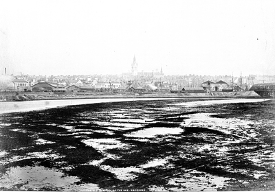
Poynernook Road was built on reclaimed River Bed Land following the Diversion of the River Dee from its original Northbound Course to the new Southern Diversion Channel and thus creating the Albert Basin terminating at Palmerston Quay. The 1st Image shows beyond the reclining Gentleman the Cofferdam built to enable the Digging of the New Southerly Channel with the Upper Dock Inches area in the distance with the 1st Joint Station and the old Guild Street now the Goods Station to the left. The 2nd inset image shows the original Northern Course of the River Dee past the Bank area called the ‘Inches‘ with its 3-Upper Dock Shipyards and supporting Sawmills on the Inches Bank and on the extreme right a Temporary Wooden Covered Bridge has been Built over to access the Point Law Inche seemingly in line with the Cross Quay. After the North Bank of the new Channel had been built up with Granite Blocks, the uneven ground left by the old Course of the River was re-levelled with the Spoil & Dredgings and the reclaimed area became Fued for Fish Curing Works and other Industrial Premises.
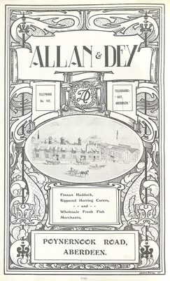
Allan & Dey, Fish Merchants & Curers, Poynernook Road
The Site of the former Aberdeen Seafood Park. with its Single-Storey Industrial Units running along the Raik Road, Stell Road, Old Ford Road & North Esplanade West Boundaries with access from Palmerston Road to Poynernook Road. All built on Land reclaimed from the old North Channel of the River Dee.
Since being Established in 1890 in Aberdeen, Allan & Dey remains a major influence in the Development of Fish processing & Trading now from 45 Sinclair Road Aberdeen. Today they continue to respond to the ever-changing demands of the Seafood Industry, showing its ability to adapt both to availability of Species & Customer trends. Now trading in fresh, frozen, smoked & shellfish products and dominate in a large range of Scottish Salmon Products. This logical development prevails from many years as a player in the growth of the Scottish Farmed Salmon industry. Now a member of the Erskine Holdings Ltd Group, over the years they have played their part as Salmon Farmers & Processors and now Specialise as International Traders.

The Seafood Park Site lay within a traditional Industrial Area of Aberdeen that predominantly accommodated Industries associated with the Albert Basin Fishing Vessel Harbour, namely Fish Processing, Smoke Houses & Distribution Premises. The Buildings surrounding the Site till recently and accommodate all types of Food Processing & Canning operations, particularly on Old Ford Road, Raik Road, Stell Road & Poynernook Road.
The now long-neglected Seafood Park in the Harbour Area of the City will now transform the Site into the new North Sea Headquarters for Oil Company EnQuest.

Ripley’s Patent Switchback Railway
It drew a large crowd when it opened in July 1889. Built almost entirely of wood, it was situated on The Inches, on the reclaimed Ground, alongside the Dee. The Site was on the former Corporation Tram Depot. The Industrial background of Commercial Buildings & many Smoking Chimneys in Poynernook have been erased in this Left image. Very primitive in Construction by present-day standards with its Straight Course of 115ft, standing 27ft high, its 3-Drops were 20ft, 15ft & 3ft. No doubt exciting enough in the mid-Victorian period.

The Switchback Railway Entrance festooned with Adverts and showing the oft erased Backgound Scene of Industrial Pollution Squalour of Smokestacks, Provision Canneries, Fish Curing Stations & Railway Arches of the reclaimed old River Channel Ground of the Poynernook Area.
The Aberdeen Gas Light Co was formed in 1824, when Works were erected at Poynernook, near Guild Street. During the 1st 4-yrs, only Oil-gas was manufactured, which was sold at 40/- to 50/- per 1,000 cu ft. In 1828 the Manufacture of Coal-gas was commenced, which reduced the price to 15/- per 1,000.
A rival Company called the New Gas Light Co was started in 1814, and Works were erected at Sandilands, which was the Site of the later Corporation & then National Gas Works. Gas at that time cost 9/- per 1,000 cu ft.
Two years later the 2 Companies were Amalgamated, and the Works at Poynernook were abandoned. In 1871 the whole undertaking was transferred to the Town Council by Act of Parliament. At that time the charge was 1/-5d per 1,000 cu ft, which had steadily decreased. In 1872 the Gas Manufactured amounted to 146M cu ft, which has risen to 725M cubic feet in 1907.
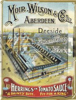
Moir, Wilson & Co, Fish Curers & Merchants, Deeside Preserved Provision Works, Old Ford Road (from North Esplanade West to Palmerston Road)
Aberdeen Ice Manufacturing Co
Police Stables – were central Northside on Poynernook Road
P Berry, Blacksmith (Farrier)
James Clark, Carter, Poynernook Road & 48 Palmerston Road
James Deans, Fish Merchant
James Minty, Cleansing Inspector. James Johnston, Manager
D B Walker, Fish curer
Allan & Dey, Fish Merchants & Curers, Poynernook Road
Bon-Accord Fish Curing Works, John T Kindness, Poynernook Road.
Robert Sinclair, Poynernook Road
John Brodie, Poynernook Road
Smith & Leys, Poynernook Road
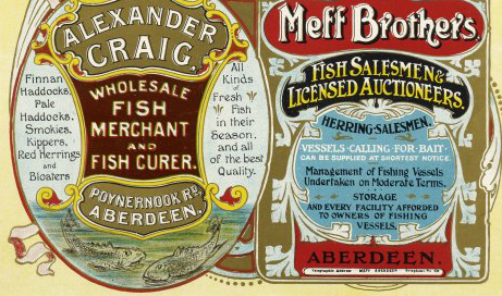
Andrew Craig, Raik Road, Alexander Craig, Poynernook Road.
John Harry Cusens, Old Ford Road
Franklin & Co, Stell Road
C F Paton & Co, Fish Curer, Old Ford Road, c.1904
Robert H Strachan, Stell Road
Donald Sinclair, Old Ford Road
Robert Sinclair, Poynernook Road
Walker & King, Raik Road
Douglas Westland, Raik Road
Corporation Cleansing Department Buildings in Poynernook Road
National Fish Curing Co, Poynernook Road & North Esplanade West c.1941
Established for almost 40-yrs, A G D Duff & Partners, 2 Stell Road were a Wholesale Fish Merchants, supplying to a range of Customers including Supermarket Chains, Hotels, Restaurants & Shops across Europe
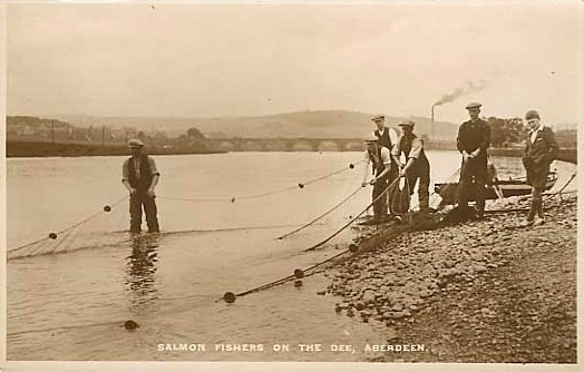
The Ancient Salmon Fishings in the River Dee from Footdee up to the Waterloo Bridge at Craiglug so jealously guarded by the Net & Coble Fishermen were named as the Stell, Raik, Inche & the Mid-Chingle Fishings.
Note the Map reference to Pynner Nook Area above the Clayhills Brickworks & Kiln Area near Portland street home of John Auldjo.
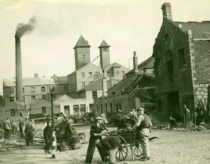
Stell Road Bomb Damage
The 2 Separate Towers in the images above & below belong to the Caledonian Milling Co (one of them a Water Tower) each projecting from their Roof. It later became a Fish-meal Factory. Above are the Caledonian Milling Co Premises beyond in Palmerston Road with its Boiler Chimney Stack & 2-High Towers – One of which was a Water Tower.
This Fishing may have been the re-designated Mid Shingle Fishing after the River was redirected South & Land was reclaimed to form North Esplanade West & the Poynernook Area where many Fish Curing Factories were Established. To the extreme right on the North Esplanade West is the Tram Depot.
The Tram Depot opened in 1904 at North Esplanade West (Right on above Image)and was the Paint Shop from 1910 to 1931. Built c.1903.
A Tall 1-Storey, 1-Bay x 6-Bay Ashlar Building with a round-headed End Door surmounted by a Pediment. The Bays are separated by Pilasters.
Arthur Clyne, Architect c.1903. Rectangular-Plan Classical former Tram Depot on prominent Corner Site. Coursed grey rough-faced Granite finely finished to Margins. Pink Granite rough-faced Base Course; Moulded Lintels to windows; finely finished Pink Granite Pilastered Bays; Pink Granite Eaves Course & Cornice; Eaves blocking course. North West (Principal) Elevation: symmetrical; large Pink Granite, stop-chamfered, Round-arched Tram Entrance to Centre, Hoodmould with decorative paired Label Stops; flanked to left & right by Pilasters supporting simple Pediment with Pink Granite Dressings.